Extent of prohibition
The consumption of liquor is prohibited and the possession of liquor is prohibited.
Period of prohibition
Continuous, provided that where:
(a) an event of historic, cultural, traditional or major community significance is held in the area; and
(b) the consumption and possession of liquor in the area (or a defined portion of the area) are authorised for a specified period for the purposes of the event by The Berri Barmera Council, the prohibition does not apply in the area (or defined portion of the area) during that specified period.
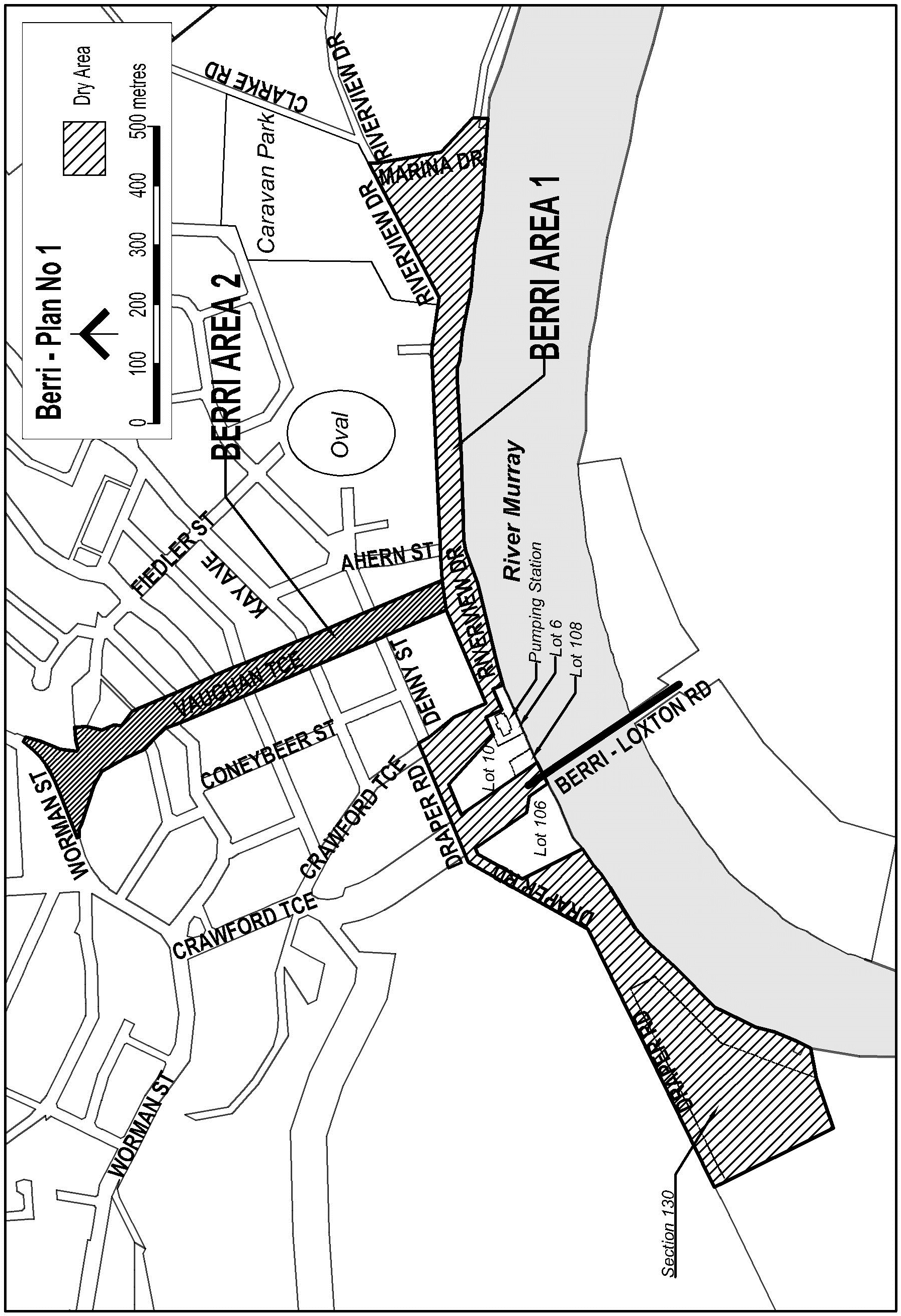
Description of area
The area in and adjacent to Berri bounded as follows: commencing at the point at which the northern boundary of Riverview Drive is intersected by the prolongation in a straight line of the eastern boundary of Marina Drive, then generally south-easterly along that prolongation and boundary to the point at which the road first turns easterly parallel to the northern bank of the River Murray, then in a straight line by the shortest route to the northern bank of the river, then generally westerly along the northern bank of the river to the point at which the northern bank meets the eastern boundary of Lot 6 DP 44333 (the pumping station), then north-westerly, south-westerly, north-westerly and south-westerly along that boundary of Lot 6 to the eastern boundary of Lot 10 DP 50410, then north-westerly and south-westerly along the boundary of Lot 10 to the western boundary of the Lot, then south-easterly along the western boundary of Lot 10 and of Lot 108 DP 49267 to the northern bank of the River Murray, then south-westerly along that bank of the river to the eastern boundary of Lot 106 DP 49267, then generally north-westerly, south-westerly and south-easterly around the boundary of Lot 106 back to the northern bank of the River Murray, then generally south-westerly along that bank of the river to the point at which the bank is intersected by the prolongation in a straight line of the southern boundary of Section 130 Berri IA, then south-westerly along that prolongation and boundary of Section 130 to the western boundary of the Section, then north-westerly along the western boundary of the Section and the prolongation in a straight line of that boundary to the northern boundary of Draper Road, then generally north-easterly along that boundary of Draper Road and the prolongation in a straight line of that boundary to the eastern boundary of Crawford Terrace, then south-easterly along that boundary of Crawford Terrace to the northern boundary of Riverview Drive, then generally north-easterly, easterly and north-easterly along that northern boundary of Riverview Drive to the point of commencement. The area includes the whole of any wharf, jetty, boat ramp or other structure extending into the River Murray from within the area described above (other than the Berri Bridge south of the northern bank of the river).
Map of area