Extent of prohibition
The consumption of liquor is prohibited and the possession of liquor is prohibited.
Period of prohibition
Continuous.
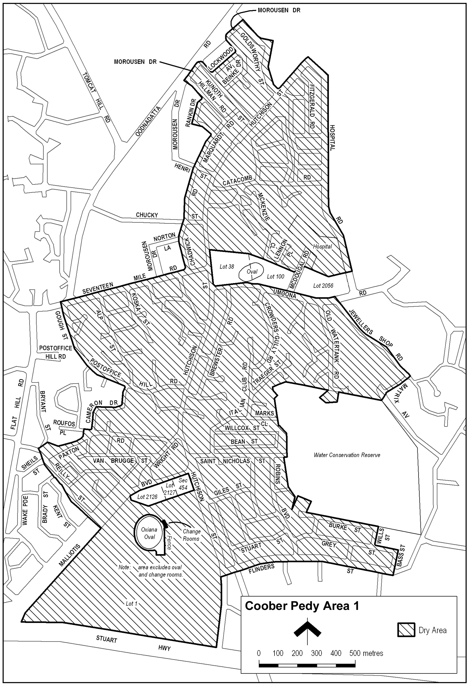
Description of area
The area at Coober Pedy bounded as follows: commencing at the point at which the prolongation in a straight line of the southern boundary of Flinders Street intersects the western boundary of Hutchison Street, then southerly along that boundary of Hutchison Street to the northern boundary of the Stuart Highway, then generally westerly along that boundary of the Stuart Highway to the south-eastern boundary of Malliotis Boulevard, then generally north-easterly along that boundary of Malliotis Boulevard to its intersection with the prolongation in a straight line of the south-western boundary of Reilly Street, then north-westerly along that prolongation and boundary of Reilly Street to the northern end of Reilly Street, then in a straight line to the nearest point on the northern boundary of Paxton Road, then generally north-easterly along that boundary of Paxton Road to its intersection with the western boundary of Cameron Drive, then northerly, easterly and northerly along that boundary of Cameron Drive to the southern boundary of Post Office Hill Road, then generally north-westerly along that boundary of Post Office Hill Road to its intersection with the prolongation in a straight line of the western boundary of Gough Street, then generally north-westerly along that prolongation and boundary of Gough Street and the prolongation in a straight line of that boundary to the northern boundary of Seventeen Mile Road, then north-easterly along that boundary of Seventeen Mile Road to the western boundary of Chadwick Road, then generally northerly and north-easterly along that boundary of Chadwick Road and Marquardt Road to the south-western boundary of Rankin Drive, then westerly and northerly along that boundary of Rankin Drive to the south-western boundary of Hillman Road, then north-westerly along that boundary of Hillman Road and the prolongation in a straight line of that boundary to the north-western boundary of Morousen Drive, then north-easterly along that boundary of Morousen Drive to its intersection with the prolongation in a straight line of the north-eastern boundary of Kunoth Street, then south-easterly along that boundary of Kunoth Street to the north-western boundary of Lockwood Avenue, then north-easterly along that boundary of Lockwood Avenue to the south-western boundary of Beinke Drive, then north-westerly along that boundary of Beinke Drive and the prolongation in a straight line of that boundary to the north-western boundary of Morousen Drive, then north-easterly along that boundary of Morousen Drive to the prolongation in a straight line of the north-eastern boundary of Goldsworthy Street, then generally south-easterly and southerly along that boundary of Goldsworthy Street to its intersection with the north-western boundary of Hutchison Street, then north-easterly along that boundary of Hutchison Street to its intersection with the prolongation in a straight line of the north-eastern boundary of Hospital Road, then generally south-easterly and southerly along that boundary of Hospital Road to its intersection with the prolongation in a straight line of the northern boundary of allotment 2056 FP 40339, then generally westerly along that prolongation and northern boundary of allotment 2056 to the eastern boundary of McDougal Road, then in a straight line by the shortest route across McDougal Road to the north-east corner of allotment 100 DP 43027, then generally westerly along the northern boundary of allotment 100 and Town allotment 38 to the eastern boundary of Hutchison Street, then southerly along that boundary of Hutchison Street to the northern boundary of Umoona Road, then generally easterly along that boundary of Umoona Road to its intersection with the prolongation in a straight line of the north-eastern boundary of Jewellers Shop Road, then generally south-easterly along that prolongation and boundary of Jewellers Shop Road to its intersection with the prolongation in a straight line of the south-eastern boundary of Matrix Avenue, then south-westerly along that prolongation and boundary of Matrix Avenue to the point at which the Avenue turns south-easterly, then in a straight line by the shortest route across Matrix Avenue to the north-east corner of the Water Conservation Reserve (Lot 1 DP 29267), then generally westerly, southerly and easterly along the northern, western and southern boundaries of the Reserve to the intersection between the southern boundary of the Reserve and the prolongation in a straight line of the eastern boundary of Wills Street, then southerly along that prolongation and eastern boundary of Wills Street to the northern boundary of Grey Street, then easterly along that boundary of Grey Street to its intersection with the prolongation in a straight line of the eastern boundary of Bass Street, then southerly along that prolongation and boundary of Bass Street and the prolongation in a straight line of that boundary of Bass Street to its intersection with the southern boundary of Flinders Street, then westerly along that southern boundary of Flinders Street and the prolongation in a straight line of that southern boundary to the point of commencement, but excluding the following areas:
(a) Lots 2126 and 2127 Deposited Plan No. 38624;
(b) Section 454 Out of Hundreds (Coober Pedy);
(c) Oxiana Oval and the adjacent change rooms on Lot 1 Deposited Plan No. 32949, being the oval and change room area on that Lot that is enclosed by a metal fence and by the northern, eastern and southern outer walls of the adjacent change rooms.
Map of area