Extent of prohibition
The consumption of liquor is prohibited and the possession of liquor is prohibited.
Period of prohibition
Continuous, but excluding the following periods:
(a) any day or days during that period on which a festival, exhibition, show or other event is held within the area if it
- (i) is of historic, traditional or cultural significance or significantly promotes tourism; and
- (ii) has been authorised by the City of Holdfast Bay for the purposes of these regulations.
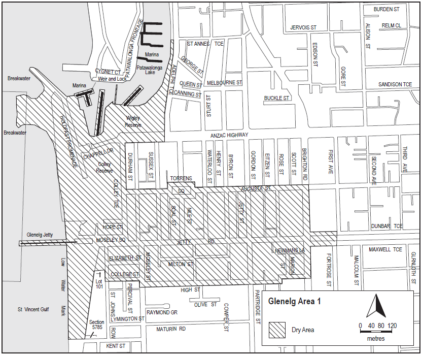
Description of area
The area in Glenelg bounded as follows: commencing at the point at which the eastern boundary of Colley Terrace intersects the northern boundary of Augusta Street, then generally easterly along the northern boundary of Augusta Street (including around the western, northern and eastern boundaries of Torrens Square) to its intersection with the eastern boundary of Brighton Road, then southerly along that boundary of Brighton Road to the northern boundary of Dunbar Terrace, then easterly along that boundary of Dunbar Terrace to the point at which it meets the western boundary of First Avenue, then in a straight line by the shortest route (across Dunbar Terrace and Maxwell Terrace) to the point at which the southern boundary of Maxwell Terrace meets the eastern boundary of Fortrose Street, then westerly along that boundary of Maxwell Terrace to the eastern boundary of Brighton Road, then southerly along that boundary of Brighton Road to its intersection with the prolongation in a straight line of the southern boundary of High Street, then generally westerly along that prolongation and boundary of High Street to the point at which the prolongation in a straight line of that southern boundary of High Street intersects the western boundary of Moseley Street, then northerly along that boundary of Moseley Street to the southern boundary of College Street, then westerly along that boundary of College Street and the prolongation in a straight line of that boundary to the western boundary of St John's Row, then northerly along that boundary of St John's Row to the southern boundary of South Esplanade Lane (the northern boundary of Lot 101 FP 6859), then westerly along that boundary of South Esplanade Lane to the eastern boundary of the South Esplanade, then south-westerly along that boundary of the South Esplanade to the northern boundary of Kent Street, then westerly along that boundary of Kent Street and the prolongation in a straight line of that boundary to the low water mark of Gulf St Vincent, then generally northerly along the low water mark (including the low water mark around the outer boundary of any breakwater or groyne) to the entrance to the Patawalonga River, then generally south easterly, easterly, northerly, easterly and northerly along the southern and eastern bank of the River to the point at which the eastern bank of the River intersects the prolongation in a straight line of the southern boundary of St Anne's Terrace, then easterly along that prolongation to the western boundary of Adelphi Terrace, then southerly along that western boundary of Adelphi Terrace and the prolongation in a straight line of that boundary to the southern boundary of Anzac Highway, then westerly along that boundary of Anzac Highway to the eastern boundary of Colley Terrace, then southerly along that boundary of Colley Terrace to the point of commencement. The area includes the Glenelg Jetty and any other jetty, wharf, mooring, dock or other structure (apart from the Patawalonga Weir) projecting into the Gulf or River from the area described above, as well as any area beneath such a structure.
Map of area