Extent of prohibition
The consumption of liquor is prohibited and the possession of liquor is prohibited.
Period of prohibition
From 9 pm on each day to 9 am on the following day and excluding any day or portion of a day, ongoing, during which:
a) an event of historic, traditional, cultural or major community significance is held within the area; and
b) the consumption and possession of liquor in the area (or a defined portion of the area) are authorized for the purposes of the event by the Mount Barker District Council, the prohibition does not apply in the area (or defined portion of the area) during that specified event.
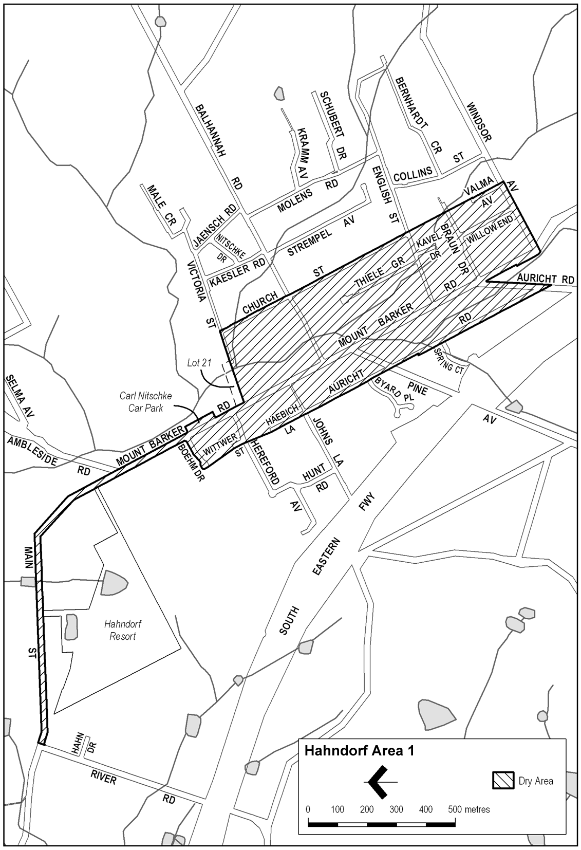
Description of area
The area at Hahndorf bounded as follows: commencing at the point at which the eastern boundary of that portion of Auricht Road that runs approximately north/south meets the prolongation in a straight line of the south-western boundary of that portion of Auricht Road that runs approximately north-west/south-east, then north-westerly along that prolongation and the south-western boundary of the latter portion of Auricht Road and the south-western boundary of Haebich Lane to the end of Haebich Lane, then in a straight line by the shortest route to the point at which the south-western boundary of Wittwer Street meets the north-western boundary of Hereford Avenue, then north-westerly along that south-western boundary of Wittwer Street to the end of the Street, then in a straight line by the shortest route to the south-eastern boundary of Boehm Drive at the south-western end of that Drive, then generally north-westerly and north-easterly around the south-western and north-western boundaries of Boehm Drive to the south-western boundary of Mount Barker Road, then generally north-westerly and westerly along that boundary of Mount Barker Road to its intersection with the south-eastern boundary of River Road, then north-easterly along the prolongation in a straight line of that boundary of River Road to the northern boundary of Mount Barker Road, then generally easterly and south-easterly along that boundary of Mount Barker Road to the point at which it meets the fence forming the north-western boundary of the Carl Nitschke Carpark, then north-easterly, south-easterly and south-westerly along the line of that fence as it forms the north-western, north-eastern and south-eastern boundaries of the car park back to the north-eastern boundary of Mount Barker Road (so as to include the car park within the area), then south-easterly along that boundary of Mount Barker Road to the point at which it intersects the prolongation in a straight line of the north-western boundary of Victoria Street (the south-eastern boundary of Lot 21 DP 82), then north-easterly along that prolongation and boundary of Victoria Street to its intersection with the prolongation in a straight line of the north-eastern boundary of Church Street, then south-easterly along that prolongation and boundary of Church Street to the south-eastern end of Church Street, then in a straight line by the shortest route to the north-eastern boundary of Valma Avenue at the north-western end of that Avenue, then south-easterly along the north-eastern boundary of Valma Avenue and the prolongation in a straight line of that boundary to the south-eastern boundary of Windsor Avenue, then south-westerly along that boundary of Windsor Avenue and the prolongation in a straight line of that boundary to the south-western boundary of Mount Barker Road, then north-westerly along that boundary of Mount Barker Road to the point at which it intersects the eastern boundary of that portion of Auricht Road that runs approximately north/south, then southerly along that boundary of that portion of Auricht Road to the point of commencement.
Map of area