Extent of prohibition
The consumption of liquor is prohibited and the possession of liquor is prohibited.
Period of prohibition
From 10 pm on each day to 6 am on the following day.
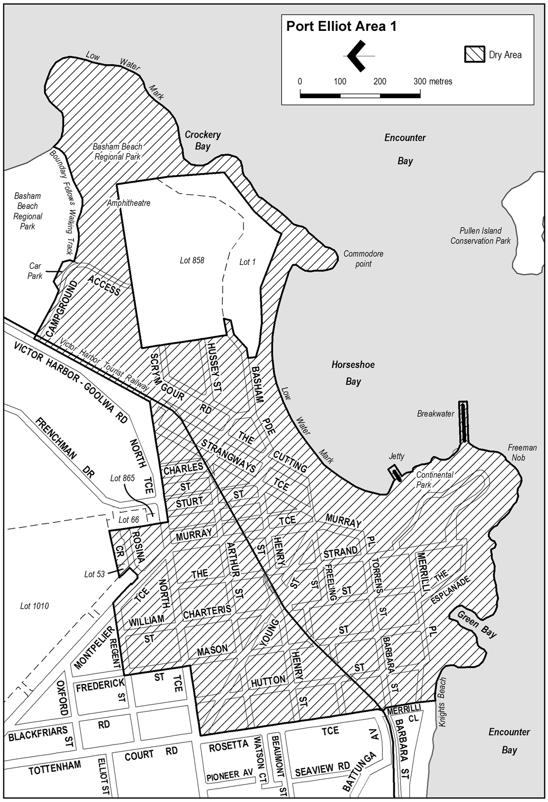
Description of area
The area in and adjacent to Port Elliot bounded as follows: commencing at the point at which the eastern boundary of Rosetta Terrace meets the southern boundary of North Terrace, then easterly along that boundary of North Terrace to the point at which it meets the western boundary of Mason Street, then in a straight line by the shortest route (across North Terrace) to the point at which the northern boundary of North Terrace meets the western boundary of Frederick Street, then northerly along the western boundary of Frederick Street to the point at which it intersects the northern boundary of Regent Street, then easterly along that northern boundary of Regent Street and the prolongation in a straight line of that northern boundary to the eastern boundary of Montpelier Terrace, then south-easterly along that boundary of Montpelier Terrace to the northern boundary of Rosina Crescent, then north-easterly along the northern boundary of Rosina Crescent to the western boundary of Lot 53 Deposited Plan 27840, then north-westerly along the western boundary of that Lot to the southern boundary of Lot 1010 Deposited Plan 52390, then easterly along that boundary of Lot 1010 to the western boundary of Lot 66 Deposited Plan 30324, then southerly along the western boundary of Lot 66 and the western boundary of Lot 865 Filed Plan 166114 and the prolongation in a straight line of that boundary of Lot 865 to the southern boundary of North Terrace, then easterly and north-easterly along that boundary of North Terrace and the southern boundary of the Victor Harbor - Goolwa Road to the northern boundary of the access road from the Victor Harbor - Goolwa Road to the Port Elliot Caravan Park, then south-easterly along the northern boundary of the access road to a car parking area on the northern side of that road, then around the outer boundary of the car park (so as to include the car park in the area) to the northern boundary of a walking track leading from the car park in an easterly direction to the beach, then generally easterly along the northern side of that walking track to the point at which the track reaches the beach, then in a straight line by the shortest route from the eastern end of the track to the low water mark on Encounter Bay, then generally easterly, south-westerly, northerly, south-westerly, south-easterly and westerly along the low water mark (including around the seaward boundary of any wharf, jetty, breakwater, boat ramp or other structure projecting below low water mark) to the point at which the low water mark is intersected by the prolongation in a straight line of the eastern boundary of Merrilli Close, then northerly along that prolongation and boundary of Merrilli Close and the eastern boundary of Rosetta Terrace to the point of commencement. The area does not include the Port Elliot Caravan Park (Lot 1 Deposited Plan 52281 and Lot 858 Filed Plan 166107).
Map of area