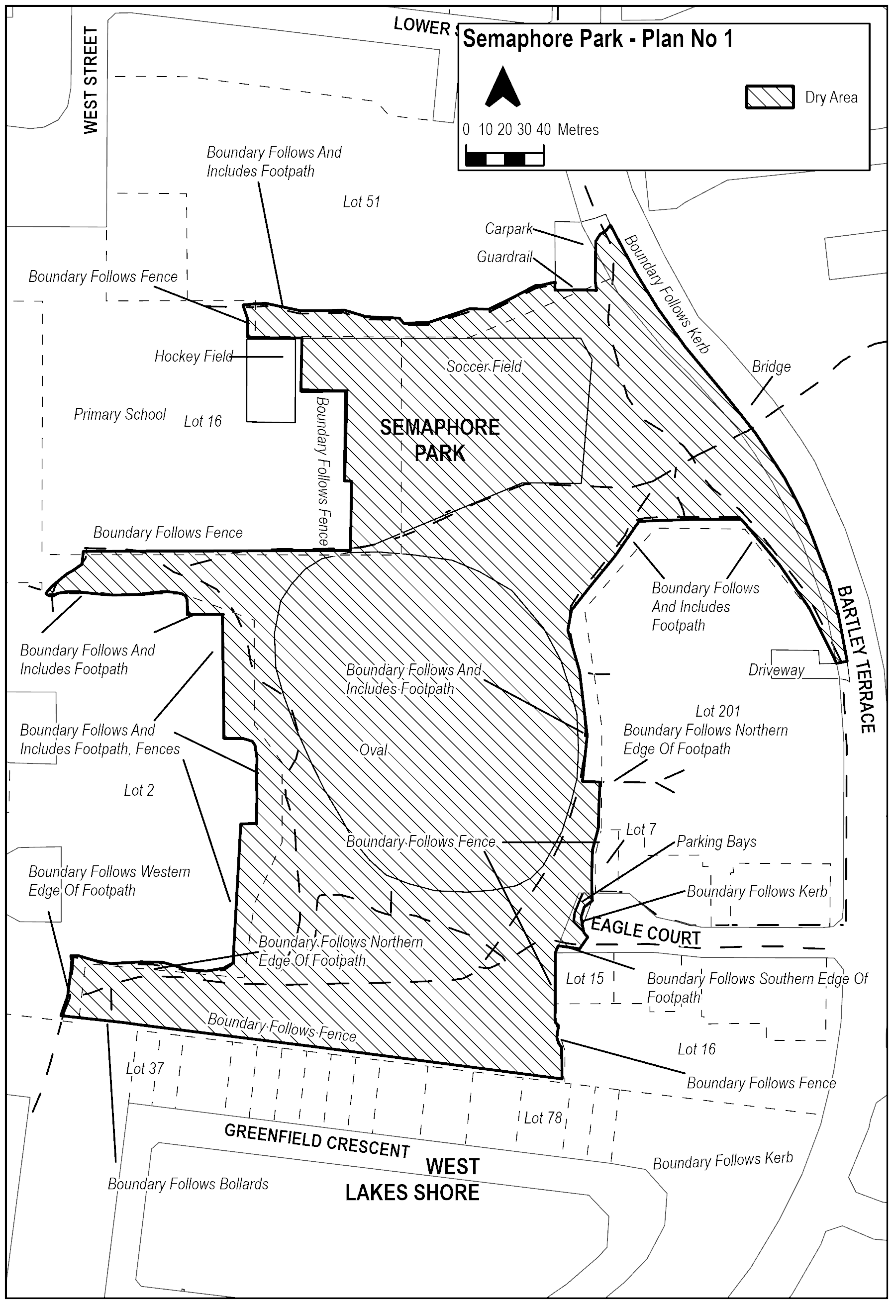
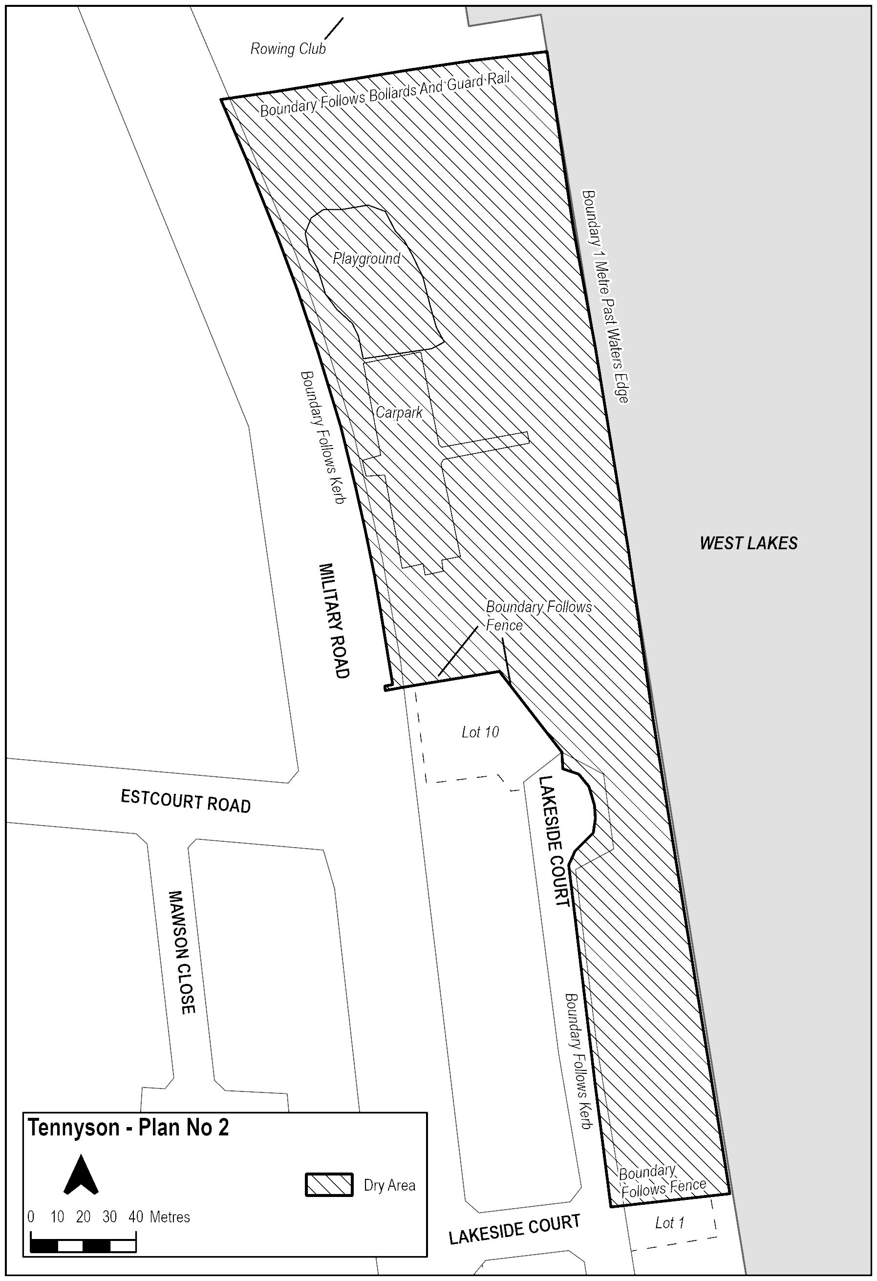
Extent of prohibition
The consumption of liquor is prohibited and the possession of liquor is prohibited.
Period of prohibition
Continuous.
Description of area
The area in Semaphore Park, known as Trust Reserve, bounded as follows:
Starting at the most North-Western corner of the hockey field of Westport Primary School, the Dry Zone Boundary travels North along the school’s fence and encompasses the reserve to the East of the fence. The Boundary stops on the Northern side of the footpath at the rear of the residential properties on West Street, Semaphore Park and follows the Northern edge of the footpath East toward Bartley Terrace. The Dry Zone Boundary remains on the reserve (including the kerb of the reserve) until it meets the Western edge of the carpark. It then travels South for the length of the footpath until level with the guardrail South of the carpark before travelling East along the guardrail between the carpark and the Reserve. The Boundary then continues North along the Eastern edge of the carpark. The Boundary does not include the road reserve / carpark for residential properties. Dry Zone Boundary continues North along the Eastern edge of the carpark before crossing the footpath and includes the kerb of the road reserve on the West side of Bartley Terrace. The Dry Zone Boundary then follows the kerb of the road reserve South-East along the West side of Bartley Terrace before travelling South along the Bartley Terrace. Where Bartley Terrace bridges the pedestrian footpath, the Dry Zone encompasses the reserve and footpath to the West of Bartley Terrace, up until the Western edge of the bridge. The Boundary continues South along Bartley Terrace, including the kerb of the road reserve, until it reaches the Northern edge of the driveway of Lot 201 Bartley Terrace Semaphore Park. The Boundary then moves West along the Northern edge of the driveway (including the kerb of the road reserve) and crosses the footpath before travelling North-West along the Western edge of the footpath to the East of the residential properties of Lot 201 Bartley Terrace Semaphore Park until intersecting a second footpath to the West. The Boundary then travels 41 metres West along the Southern edge of the second footpath, immediately North of the private residences. It continues until meeting the Eastern edge of the main footpath of the reserve and then follows the Eastern edge of the main footpath South at the rear of the residential properties of Lot 201 Bartley Terrace, Semaphore Park. The Boundary continues past the first minor footpath leading to the residential properties of Lot 201 Bartley Terrace, Semaphore Park, until it meets the Northern edge of the second path leading to these residences. The Boundary then travels East along the Northern edge of footpath until parallel with the fence of Lot 201 Bartley Terrace Semaphore Park. The Dry Zone Boundary travels South, following the Western fences of Lot 7 Eagle Court, Semaphore Park. The Dry Zone Boundary continues South in a straight line until meeting the kerb of the road reserve of Eagle Court, Semaphore Park. It follows (and includes) the kerb of the road reserve West, South and then East around the cul de sac, including the parking bays at the Western edge of the cul de sac at Eagle Court, Semaphore Park. Once it reaches the North-Western kerb of the road reserve of Eagle Court, Semaphore Park, the Boundary travels South-West along the kerb, bordering the parking bays, until it meets the Southern edge of the footpath leading into Trust Reserve. The Boundary then follows the Southern edge of the footpath until it is level with the Western fence of Lot 15 Eagle Court Semaphore Park. It travels South in a straight line along the Western fence of Lot 15 Eagle Court, Semaphore Park, before meeting the North-Western boundary of Lot 16 Eagle Court, Semaphore Park. The Boundary then follows the Western fence of Lot 16 Eagle Court until meeting the intersecting fence along the rear of the residential properties of Greenfield Crescent, West Lakes Shore. The Dry Zone Boundary travels West along the fences at the rear of residences on Greenfield Crescent and continues in a straight line along the bollards delineating the boundary between Trust Reserve and Greenfield Reserve. The Dry Zone Boundary includes these bollards. It continues until meeting the Western edge of the North-South footpath, and then travels North along the Western edge of the footpath, toward the residential properties of Lot 2 Fairford Terrace, Semaphore Park, until it meets the North-Western edge of the intersection with the minor East-West footpath bordering the front yards of the residences at Lot 2 Fairford Terrace, Semaphore Park. The Dry Zone Boundary then travels East along the Northern edge of the footpath until level with the Western boundary of the residential properties of Lot 2 Fairford Terrace Semaphore Park. It then travels North along the Eastern boundaries of the residential properties, encompassing footpaths, fence lines or natural boundaries parallel with the Trust Reserve oval towards Westport Primary School, until it meets the North-Eastern boundary of Lot 2 Fairfield Terrace, Semaphore Park. It then travels West along the Northern boundary of the residence until meeting the Western edge of an intersecting North-South footpath. The Boundary continues North along the Western edge of this footpath, toward the primary school, before changing West along the front of the residential properties of Lot 2 Fairford Terrace, Semaphore Park. It then follows the Southern edge of the footpath approximately 60 metres until meeting the Western edge of the intersection of 3 footpaths. The Boundary then turns North-East and follows the Northern edge of the Northern footpath until it meets the fence at the Southern side of Westport Primary School. The Dry Zone Boundary continues East along the Southern fence of the Westport Primary School before entering the soccer field of Westport Primary School. It then follows the Eastern fences of Westport Primary School North until reaching the North-Eastern corner of the hockey field. The Dry Zone Boundary continues West along the Northern fence of the hockey field until meeting the North-Western corner of the field.
The area in Semaphore Park, known as Dotterel Reserve, bounded as follows:
Starting at the South-Western corner of residential address Lot 10 Dotterel Drive Semaphore Park, the Dry Zone Boundary follows the Southern fence along the edge of the property South-East toward the lake. It then continues North-East along the rear fence of the residential properties of Lots 10 to 3 Dotterel Drive, Semaphore Park before turning East along the fence of Lot 3, Lot 2 and Lot 1 Dotterel Drive. It follows the boundary of residence Lot 1 Dotterel Drive East until meeting the fence of residential address Lot 152 Dotterel Drive, Semaphore Park. The Boundary then turns North-East and follows the Western edge of the North-South footpath at the rear of the residential properties of Lot 152 Dotterel Drive Semaphore Park. It then travels North-East 5 metres to the Northern edge of the intersecting footpath leading East toward the lake before curving into Dotterel Reserve. The Boundary follows the Northern edge of the footpath until it intersects another footpath traveling North-South. From the Northern corner of that intersection the Boundary moves directly East until 1 metre past the water’s edge. The Boundary then remains 1 metre from the water’s edge as it moves South until it is level with the guardrail at the Southern edge of the carpark for Dotterel Reserve. The Boundary follows the guard rail West in a straight line along the Southern edge of the carpark, until it meets the driveway of the Dotterel Drive Boat Shed (Lot 4, Dotterel Drive). The Dry Zone Boundary then travels North-West along the Eastern edge of the driveway to the kerb of the road reserve of Dotterel Drive Semaphore Park. It then Travels North-East, and then North, along the kerb of the road reserve (excluding the parking bays) until level with the Southern fence of Lot 10 Curlew Court, Semaphore Park. The Boundary continues East along the Southern fence of the residential properties Lot 10, Lot 9 and Lot 8 Curlew Court Semaphore Park, before turning North along the fence at the rear of the Lot 8 Curlew Court Semaphore Park. It then moves East directly to the Western corner of the fence of Lot 7 Curlew Court Semaphore Park, before travelling South-East along the Southern fence of Lot 7 Curlew Court Semaphore Park. The Boundary then follows the fence along the rear of the residential properties of Curlew Court Semaphore Park North-East, and then North-West approximately 12 metres until intersecting a fence on the Northern boundary of Lot 5 Curlew Court Semaphore Park. It continues North-East in a straight line directly to the Southern fence of the property Lot 4 Curlew Court Semaphore Park. The Boundary continues to follow the fences at the rear of the residential properties North-East, until turning North-West for 6 metres along the Northern fence of Lot 1 Curlew Court Semaphore Park. The Boundary moves in a direct line North-East to meet the Eastern fence of Lot 11 Curlew Court, before following the rear fences and walls of the residential properties of Curlew Court Semaphore Park North-East and then North-West. The Dry Zone Boundary continues along the fence lines until reaching Lot 1 at the corner of Dotterel Drive and Curlew Court Semaphore Park, before following the Northern fence in a direct line to the kerb of the road reserve of Curlew Court. The Dry Zone does not include the parking bays on the road reserve. It travels North-East along the kerb of the road reserve until level with the South-Western fence of Lot 10 Dotterel Drive Semaphore Park. The Dry Zone Boundary then moves in a direct line South-East until returning where it started at the South-Western Corner of Lot 10 Dotterel Drive Semaphore Park.
Maps of areas