Extent of prohibition
The consumption of liquor is prohibited and the possession of liquor is prohibited.
Period of prohibition
Continuous.
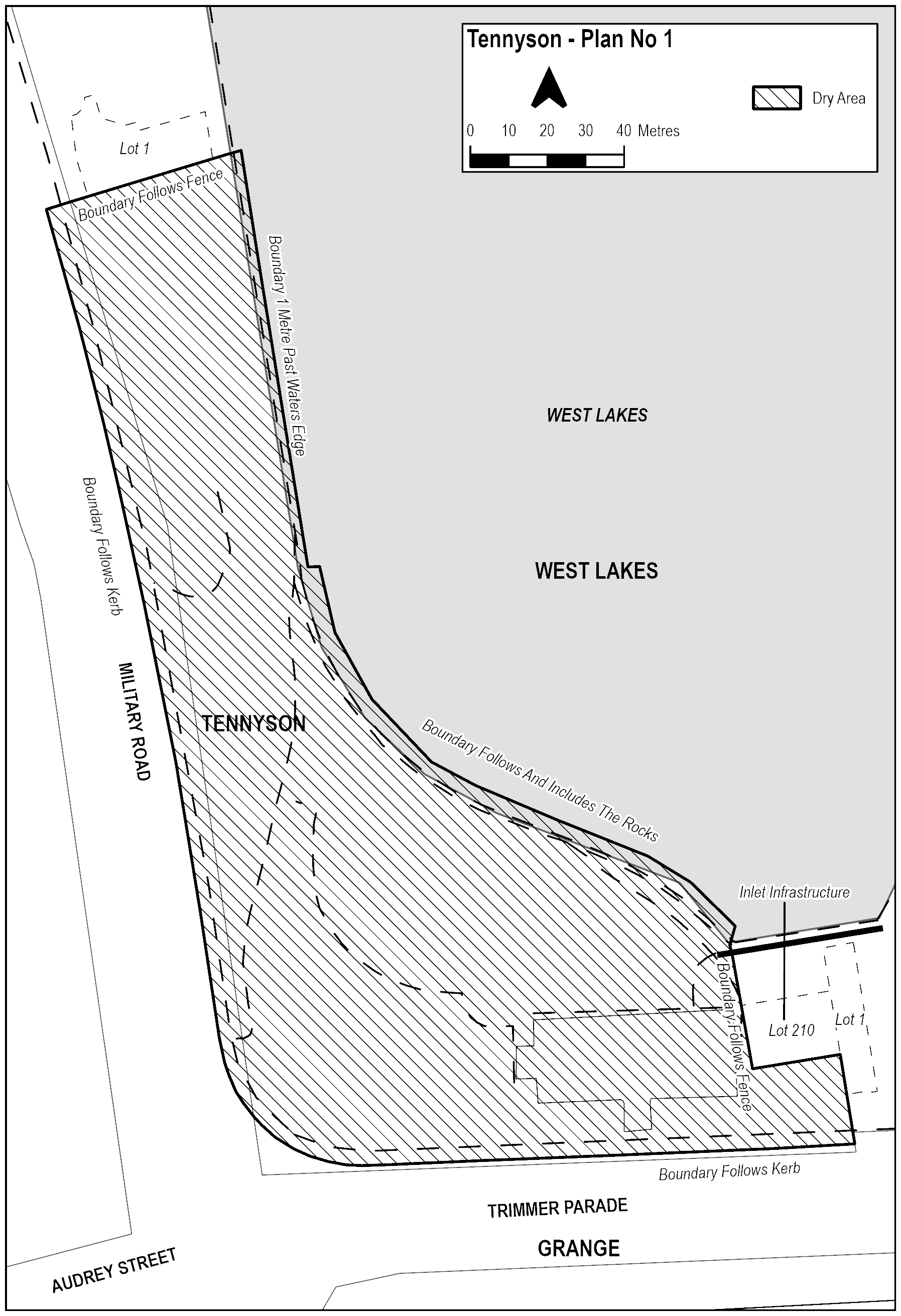
Description of area
The area in Tennyson, known as Inlet Reserve , bounded as follows:
Starting at the Western side of the carpark entrance on Trimmer Parade, the Boundary for the Dry Zone travels West along the footpath and includes the kerb of the Trimmer Parade Road reserve. The Boundary follows the kerb of the road reserve North as it becomes Military Road, and then continues North (including the footpath, verge and kerb of the Military Road road reserve) until it is level with the fence of Lot 1 Military Road, Tennyson. The Dry Zone Boundary then travels North-East along the fence of the property and then continues in a straight line until it is 1 metre past the edge of the water. The Boundary remains 1 metre from the water’s edge and travels South until it meets the rocks. The Boundary follows the water’s edge against the rocks South-East until it is level with the start of the bridge over the inlet and encompasses the surface of any rocks above the water. The Boundary of the Dry Zone then travels South across the bridge over the inlet and along the Western boundary of Lot 210 Trimmer Parade, Tennyson. At the Southern corner of the property, the Dry Zone follows the fence East until meeting the Western fence of Lot 1 Trimmer Parade, West Lakes. The Boundary then travels South-East, until it meets the kerb of the Trimmer Parade Road reserve. The Dry Zone Boundary then travels West along the Trimmer Parade Road reserve (including the kerb) until it meets the start of the Western side of the driveway off Trimmer Parade.
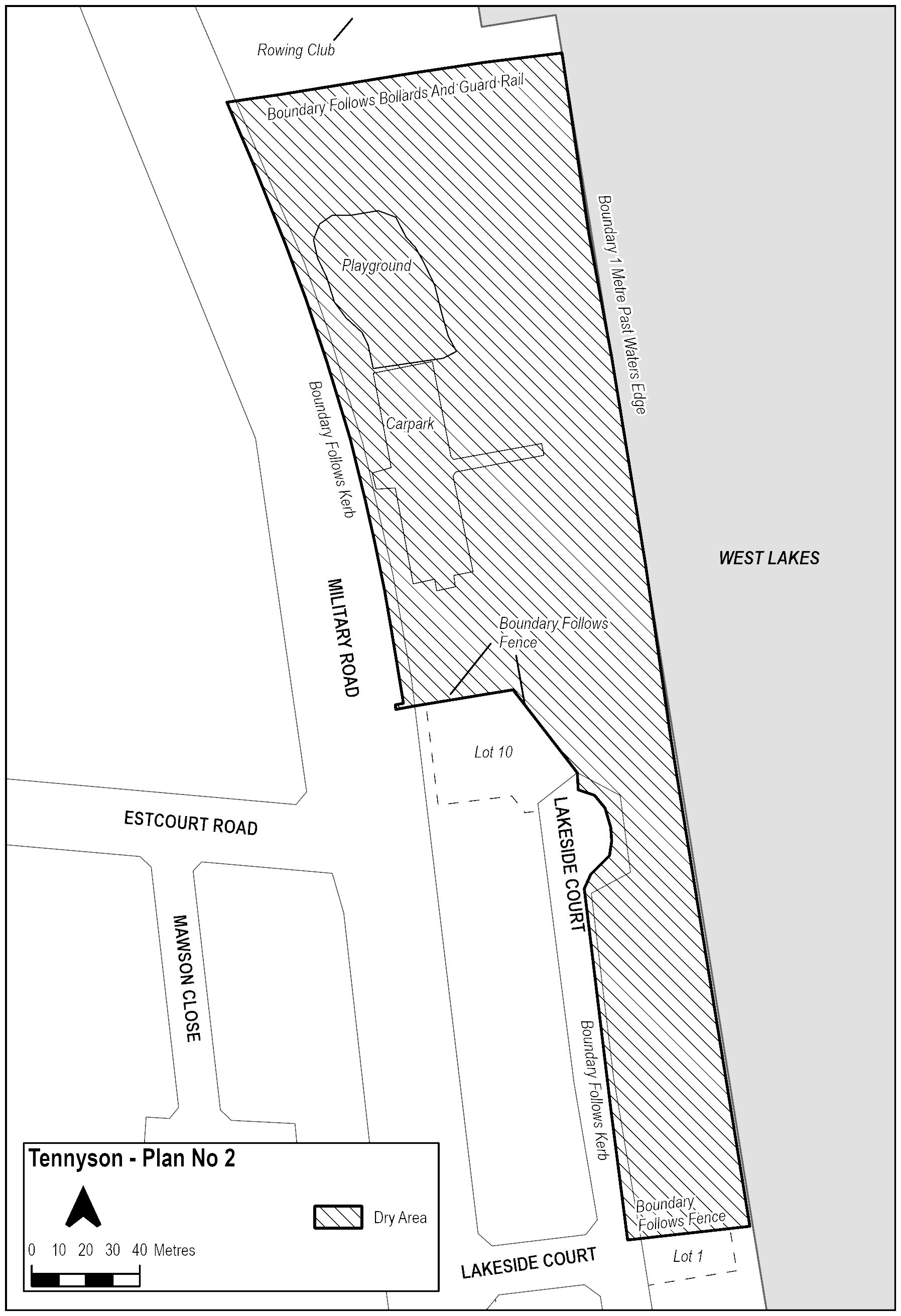
The area in Tennyson, known as Oarsman Reserve, bounded as follows:
The Dry Zone Boundary begins where the Northern boundary of Lot 1 Lakeside Court Tennyson meets the road and encompasses the kerb of the road reserve of Lakeside Court. Travelling North along Lakeside Court, the Boundary continues along the reserve (including the kerb of the road reserve) and follows the kerb of the road reserve around until it is in line with the Western boundary of Lot 10 Lakeside Court, Tennyson. The Boundary continues North until the South-Eastern corner of Lot 10 Lakeside Court Tennyson, before following the North-Eastern and then Northern fence of the property to meet the road reserve of Military Road, Tennyson. The Boundary then continues North (including the kerb) along Military Road, Tennyson, and travels across the driveway for the carpark. It follows the curve of the road reserve of Military Road North toward the Rowing Club and encompasses the car park and playground within Oarsman Reserve, but excludes the parking bays on Military Road, Tennyson. The Dry Zone turns East toward the lake 9 metres south of the driveway for the Rowing Club and continues along the guardrail depicting the boundary between the grassed reserve and parking lot. The Dry Zone Boundary continues down the beach and into the water 1 metre from the water’s edge. The Boundary remains in the water, 1 metre from the water’s edge, and travels South until level with the Northern boundary of Lot 1 Lakeside Court, West Lakes. It then travels West along the fence of the property until meeting the kerb of the road reserve where it started.
Maps of areas