Extent of prohibition
The consumption of liquor is prohibited and the possession of liquor is prohibited.
Period of prohibition
Continuous.
Description of area
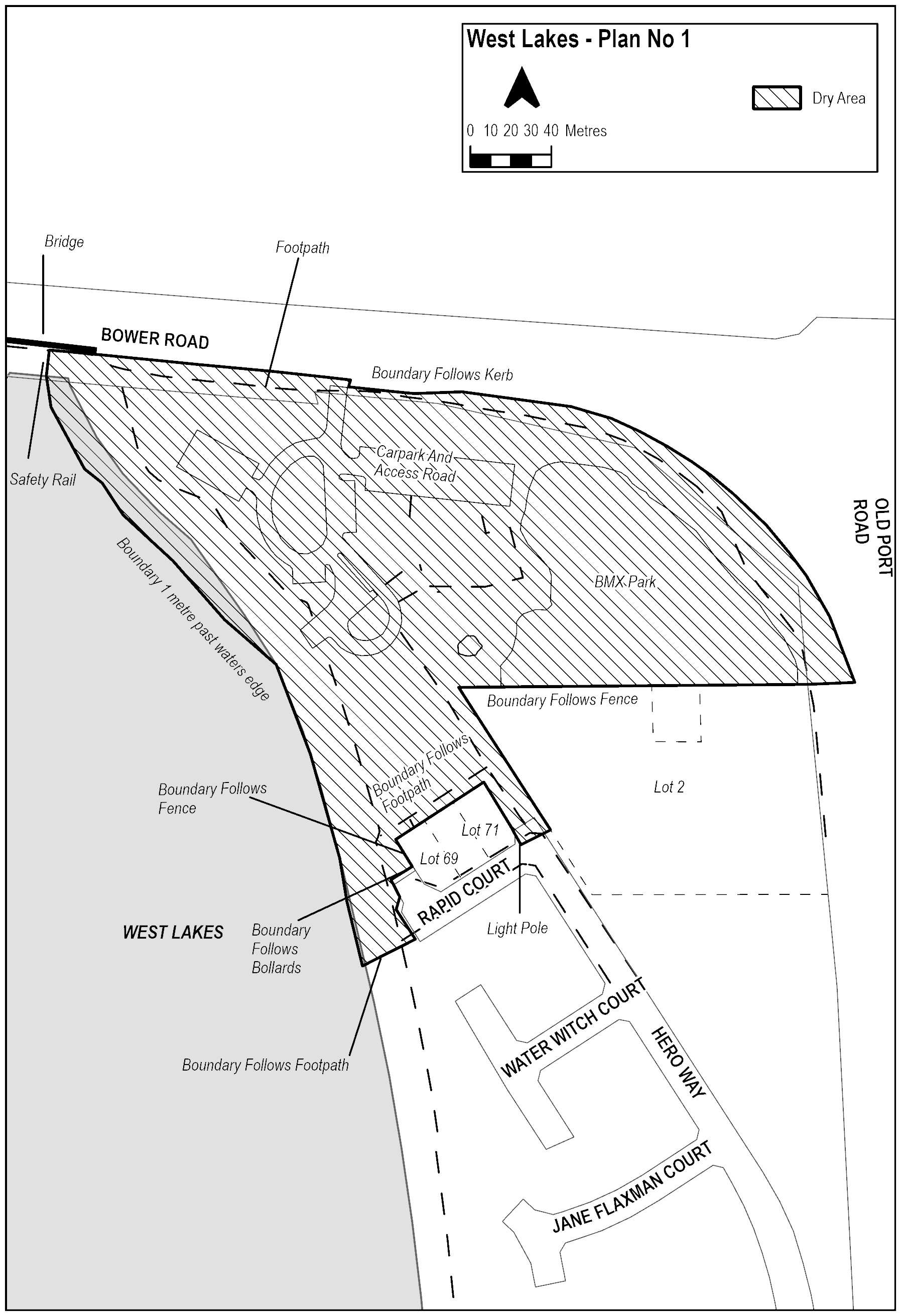
The area in West Lakes, known as Aquatic Reserve, bounded as follows:
The Dry Zone Boundary begins at the bridge on Bower Road, Semaphore Park, facing East on the kerb of the road reserve of the South side of Grand Junction Road and parallel with the Eastern safety rail of the outlet. The Boundary encompasses the path and kerb of the road reserve travelling East along Bower Road, including the driveway into Aquatic Reserve. It then turns South at the Eastern border of the Aquatic Reserve driveway, and then East to remain on the kerb of the road reserve. The Dry Zone does not include the left turn lane into Aquatic Reserve of the road reserve. The Boundary follows the kerb of the road reserve of the south side Bower Road and then follows Bower Road East toward Grand Junction Road, and then South as it becomes Old Port Road. The Boundary follows the West side of the Old Port Road road Reserve South (including the kerb) until parallel with the Northernmost boundary of Lot 2 Old Port Road, West Lakes, adjacent the BMX park. The Boundary then turns West toward the property and follows the fence of the property boundary along Aquatic Reserve. Turn South-East to follow the Western boundary of Lot 2 Old Port Road, West Lakes until it reaches a line parallel with the Northern kerb of the road reserve of Rapid Court, West Lakes where it intersects Hero Way West Lakes. The Dry Zone Boundary then turns West along the Northern kerb of the Rapid Court Road reserve until it reaches the light pole at the South-Eastern Corner of Lot 71 Rapid Court West Lakes. It then continues North along the Eastern fence of Lot 71 Rapid Court West Lakes until it reaches the Southern edge of the footpath at the rear of the residential properties of Rapid Court West Lakes. The Boundary follows the Southern edge of the footpath West, toward the lake, along the rear of the residential properties of Rapid Court, West Lakes until it reaches the North-Western corner of Lot 69 Rapid Court, West Lakes. It then travels South-East along the South-West fence of Lot 69 Rapid Court, West Lakes and continues until meeting the bollards at North side of the cul-de-sac of Rapid Court, West Lakes. The Dry Zone Boundary follows the bollards West toward the lake, and then South-East at the Western side of the cul-de-sac, until meeting the Southern edge of the footpath. The Boundary then continues West in a straight line into the lake, 1 metre passed the water’s edge. It then travels North, 1 metre from the water’s edge along the Western edge of Aquatic Reserve, toward Bower Road. It follows the line of the safety rail on the Eastern side of the outlet until it reaches the kerb of the road reserve on the Southern Side of Bower Road, Semaphore Park.
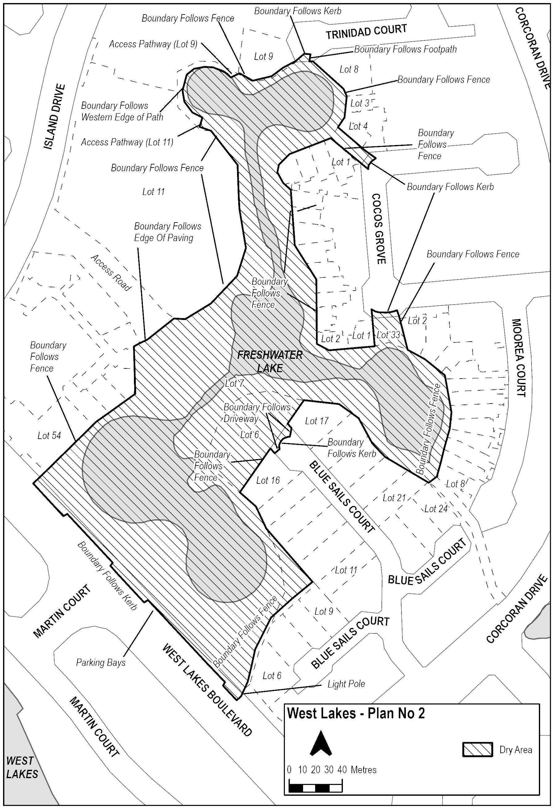
The area in West Lakes, known as Freshwater Lake and Reserve, bounded as follows:
Starting at the Western corner of the residential property Lot 6 Blue Sails Court, West Lakes, the Dry Zone Boundary moves in a straight line to the nearest light post in front of the property on West Lakes Boulevard. It then travels in a straight line South-East directly to the kerb of the road reserve of West Lakes Boulevard, before following the kerb North-East. It then continues North-East 180 metres, excluding the parking bays, but including the kerb of the road reserve, until level with the South-Eastern edge of the Lot 54 West Lakes Boulevard, West Lakes. The Boundary then travels North-West along the Western fences of properties Lot 54 West Lakes Boulevard, West Lakes and Island Drive, West Lakes. It continues North-West along the fence at the rear of the residential properties of Island Drive, West Lakes until meeting the North-Eastern edge of the paving, where the paving borders the asphalt of the access road leading to Island Drive, West Lakes. The Boundary then travels directly along the Northern edge of the paving toward the residential properties at Lot 11 Island Drive, West Lakes, before reaching the South-Eastern corner of the fence of the Southernmost property of Lot 11 Island Drive, West Lakes. The Dry Zone Boundary continues to follow the Southern and Eastern fences at the rear of the properties at Lot 11 Island Drive, West Lakes East, and then North toward the top of Freshwater Lake Reserve. The Boundary turns West and remains along the rear fences of the properties at Lot 11 Island Drive West Lakes, until the North-Western boundary of Lot 11 Island Drive, West Lakes with the path leading to the footpath around the lake. The Boundary then follows the Northern edge of the path toward the lake before travelling North-East along the Southern edge of the pathway, between the grass and the paving. It then travels along the Eastern, and then Northern, side of the footpath surrounding the lake, before meeting the pathway leading from the Western boundary of Lot 9 Trinidad Court, West Lakes. It then follows the Northern edge of the pathway toward the Southern fence of Lot 9 Trinidad Court, West Lakes, before continuing along the fence South-East, and then the property boundary North-East of Lot 9 Trinidad Court, West Lakes toward the road reserve. Once it reaches the kerb of the road reserve of Trinidad Court, it moves East (including the kerb) until meeting the Eastern edge of the footpath leading toward Freshwater Lake Reserve. The Dry Zone Boundary then travels South along the Eastern edge of the footpath until meeting the Western fence of Lot 8 Trinidad Court, West Lakes. It follows the Western fence of Lots 3-4 Trinidad Court, West Lakes South before continuing along the fences at the rear of residential properties of Trinidad Court, West Lakes. At the Western corner of Lot 4 Trinidad Court, West Lakes, the Boundary turns South-East to follow the fence toward Cocos Grove, West Lakes. At the kerb of the road reserve, it travels South along the kerb until level with the fence of Lot 1 Cocos Grove, West Lakes. The Boundary follows the fence South between Lot 7 (Freshwater Lake Reserve) and the properties abutting the reserve along Cocos Grove, until the Southern corner of Lot 2 Cocos Grove West Lakes, before turning East toward Lot 33 Cocos Grove, West Lakes (Freshwater Lake Reserve). It then follows the boundary of Lot 33 Cocos Grove, West Lakes to the kerb. The Boundary continues following the fence South-East between Lot 2 Cocos Grove and Lot 33 Cocos Grove, West Lakes before continuing along the rear fence of the properties abutting the reserve along Moorea Court and Blue Sails Court. At the South-Western corner of the fence on Lot 8 Moorea Court the Boundary proceeds in a straight line to the North-Eastern corner of the fence on Lot 21 Blue Sails Court. Proceeding in a North-Western direction along the fence line of Lot 7 (Freshwater Lake Reserve) and the abutting properties. At Lot 17 Blue Sails Court, the Boundary continues along the Western edge of the driveway to the kerb and follows the kerb to Lot 16 Blue Sails Court. Heading up the Western edge of the driveway until level with the fence between Lot 6 (Freshwater Lake Reserve) and Lot 16 Blue Sails Court, West Lakes. The Boundary continues in a straight line to the fence and proceeds to follow the fence between Lots 6 (Freshwater Lake Reserve) and Lot 16 Blue Sails Court. The Boundary continues along the fences of the properties abutting the reserve, turning South-East at the Western corner of Lot 11 Blue Sails Court, West Lakes, until meeting the start point at the Western corner of Lot 6 Blue Sails Court, West Lakes.
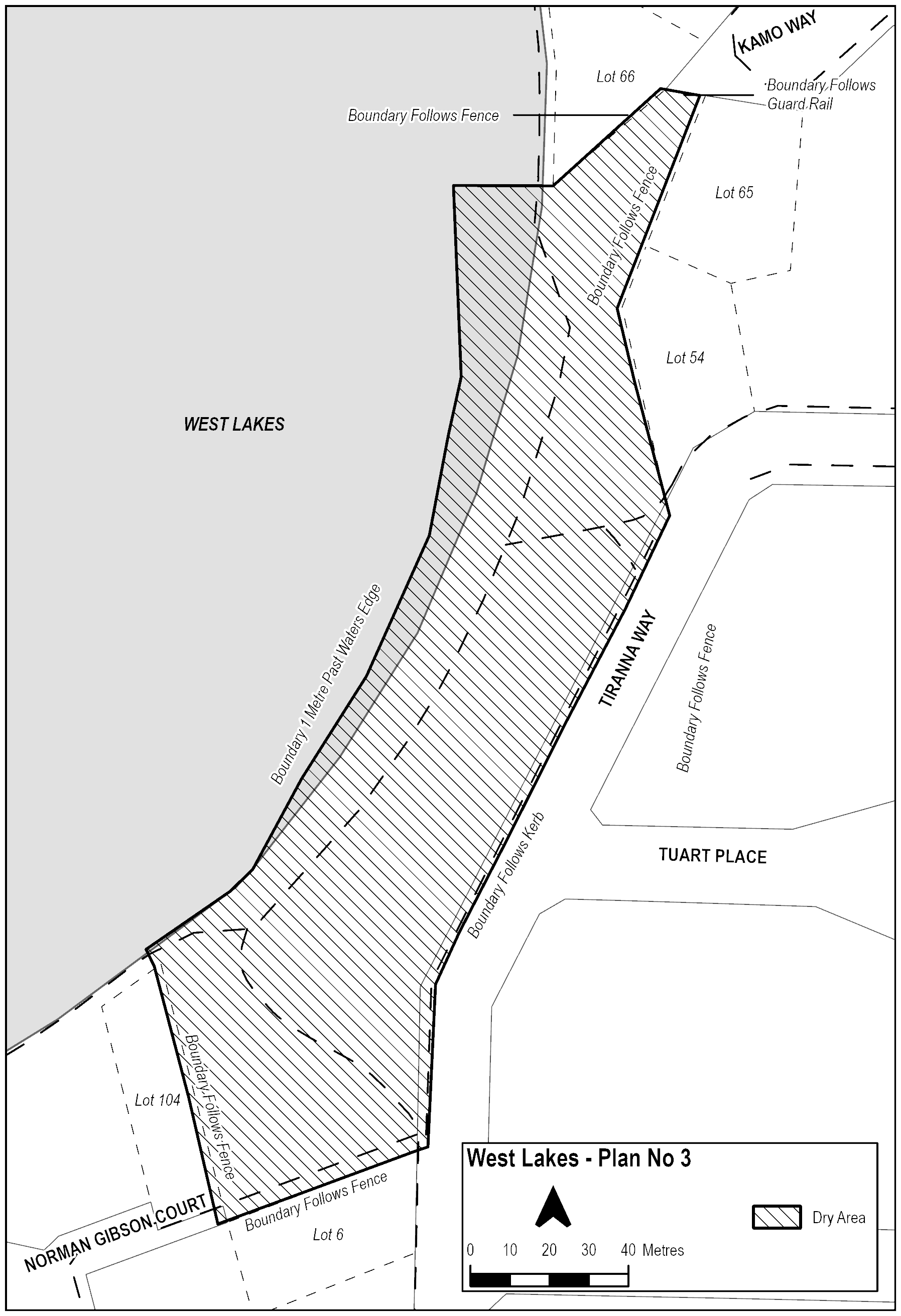
The area in West Lakes, known as Tiranna Reserve, bounded as follows:
The Boundary starts at the kerb of the road reserve of Tiranna Way, West Lakes, level with the North-Eastern fence of Lot 6 Tiranna Way, West Lakes. It travels South-West along the North-Eastern fence of the property until level with the Eastern fence of Lot 104 Norman Gibson Court West Lakes. The Boundary then continues North-East along the Eastern fence of the property toward the lake and extends 1 metre past the water’s edge. The Boundary then moves North, remaining 1 metre from the water’s edge until it is directly West of the Southern corner of Lot 66 Kamo Way, West Lakes. It travels directly East to that corner before continuing North-East along the South-Eastern boundary of Lot 66 Kamo Way, West Lakes before meeting the fence indicating the boundary of Tiranna Reserve. The Dry Zone Boundary turns East along the Northern fence of Tiranna Reserve until it meets the Western fence of Lot 65 Kamo Way West Lakes. It follows the Western fences of Lot 65 Kamo Way West Lakes and Lot 54 Tiranna Way West Lakes South, before continuing in a straight line to the kerb of the road reserve of Tiranna Way West Lakes. The Boundary then travels South-West along the kerb of the road reserve, and then South, until meeting the start point level with the North-Eastern fence of Lot 6 Tiranna Way, West Lakes.
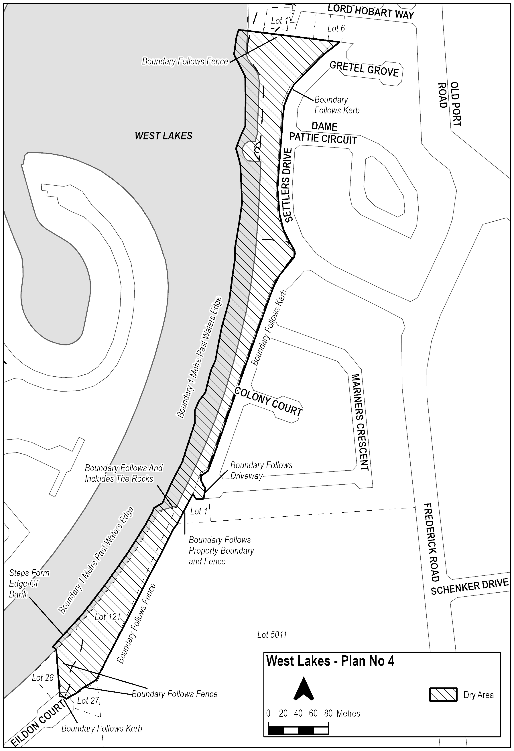
The area in West Lakes, known as Settlers and Mariners Reserves, bounded as follows:
The Dry Zone Boundary begins at the kerb of the road reserve of Eildon Court, West Lakes, level with the Eastern fence of Lot 28 Eildon Court West Lakes. The Boundary travels North along the Eastern fence of the property, and then North-West along the Mariner’s reserve fence and into the water 1 metre. The Boundary remains 1 metre past the water’s edge, encompassing the steps into the water, and travels North-East until meeting the rocks. It then continues North, encompassing the surface of any rocks above the water. The Dry Zone Boundary remains 1 metre from the water’s edge and follows the edge of the lake North until it is level with the Southern fence of the property Lot 1 Lord Hobart Way, West Lakes. It then travels East along the Southern fence at the rear of the properties on Lord Hobart Way, West Lakes, until it meets the intersection of the Eastern fence of Lot 6 Lord Hobart Way, West Lakes. From the South-Eastern corner of Lot 6 Lord Hobart Way West Lakes, the Dry Zone Boundary then moves South-West until it meets the Western edge of the road reserve of Settlers Drive. It continues South-West along the Western edge of the road reserve of Settlers Drive, including the kerb, until Settlers Drive meets Mariner’s Crescent. The Boundary follows the Western kerb of the road reserve as it flows into Mariner’s Crescent and then continues South following the kerb of the road reserve until it meets the Western edge of the driveway of Lot 1 Mariners Crescent, West Lakes. The Boundary then follows the Western edge of the driveway of the property South, before continuing West along the Northern edge of the property. At the Northern corner of Lot 1 Mariners Crescent West Lakes, the Boundary moves South along the property's Western fence and continues South-West along the fence Western fence of Lot 5011 Frederick Road, West Lakes. The Dry Zone Boundary continues until it meets the Northern corner of the property Lot 27 Eildon Court, West Lakes, and then travels South-West along the Northern fence of the property toward the road reserve of Eildon Court West Lakes. The Boundary then follows the kerb of the road reserve North-East until it reaches the start point level with the Eastern fence of Lot 28 Eildon Court West Lakes.
Maps of areas