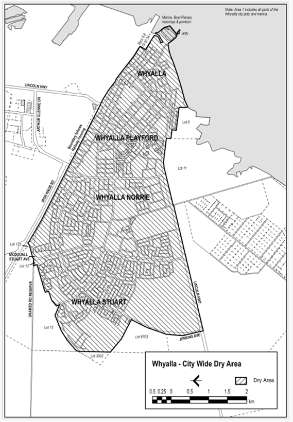
Extent of prohibition
The consumption of liquor is prohibited and the possession of liquor is prohibited.
Period of prohibition
Continuous from 1 December 2025 (as published in the Government Gazette 27 November 2025).
Description of area
Using Parcel Identifiers described on Plan SA’s SA Property and Planning Atlas, the dry area of the Corporation of the City of Whyalla township is bounded as follows:
Commencing at the eastern most boundary point of H560500SE125 (Lot 125 McBryde Terrace Whyalla Norrie), traversing anticlockwise in a north-westerly direction, following the northern boundary of H560500SE125, including the prolongation of that boundary through McDouall Stuart Avenue road reserve to the western most point of H560500SE125 then following the western boundary to the northeast corner of D74902QP14 (Lot 13 McDouall Stuart Avenue Whyalla Stuart), following the northern and western boundaries of D74902QP14 to the southeastern corner of D74902AL15 (Lot 15 McDouall Stuart Avenue Middleback Range) following its southern boundary in a westerly direction to the northern corner of D89185AL3002 (Lot 3002 Jenkins Avenue Middleback Range), following the eastern boundary of DP89185AL3002 in a southerly direction to the northern corner of T560501AL6763 (Lot 6763 Jenkins Avenue Whyalla Jenkins), following the northern boundary of T560501AL6763 to the western boundary of Jenkins Avenue road reserve, following the western boundary of Jenkins Avenue road reserve southerly to the intersection of Lincoln Highway (B100) road reserve, following the prolongation of the southwestern point of the western boundary of Jenkins Avenue road reserve to intersect with the southern boundary of Lincoln Highway (B100) road reserve, following Lincoln Highway/Broadbent Terrace (B100) road reserve southern boundary in an easterly direction to the northwestern corner of D26386AL6 (Lot 6 Newton Street Whyalla), following the northern and eastern boundaries of D26386AL6 to the shoreline, following the entire shoreline easterly, encompassing D61444AL100 (Lot 100 / 1A / 1B Cudmore Terrace Whyalla), D26088AL3 (31-58 Buttlingara Way Whyalla), breakwater, jetty and marina to the intersect of the northern most point of D26088AL3 and the Corporation of the City of Whyalla’s Local Government Boundary, following this boundary north-westerly to the southeastern point of D61915QP80 (26806 Lincoln Highway Whyalla Barson), then following the eastern and northern boundaries of D61915QP80 to Lincoln Highway (B100 / Playford Avenue extension) road reserve, following the prolongation of the northern boundary of D61915QP80 to the northwestern corner of D61915QP81 (26806 Lincoln Highway Whyalla Barson), following the northern and western boundaries of D61915QP81 to the intersect of McBryde Terrace road reserve, following the prolongation of the northern boundary of McBryde Terrace road reserve, through Arthur Glennie Drive road reserve and the continuation of the northern boundary of McBryde Terrace road reserve to the starting point of H560500SA125.