Extent of prohibition
The consumption of liquor is prohibited and the possession of liquor is prohibited.
Period of prohibition
Continuous.
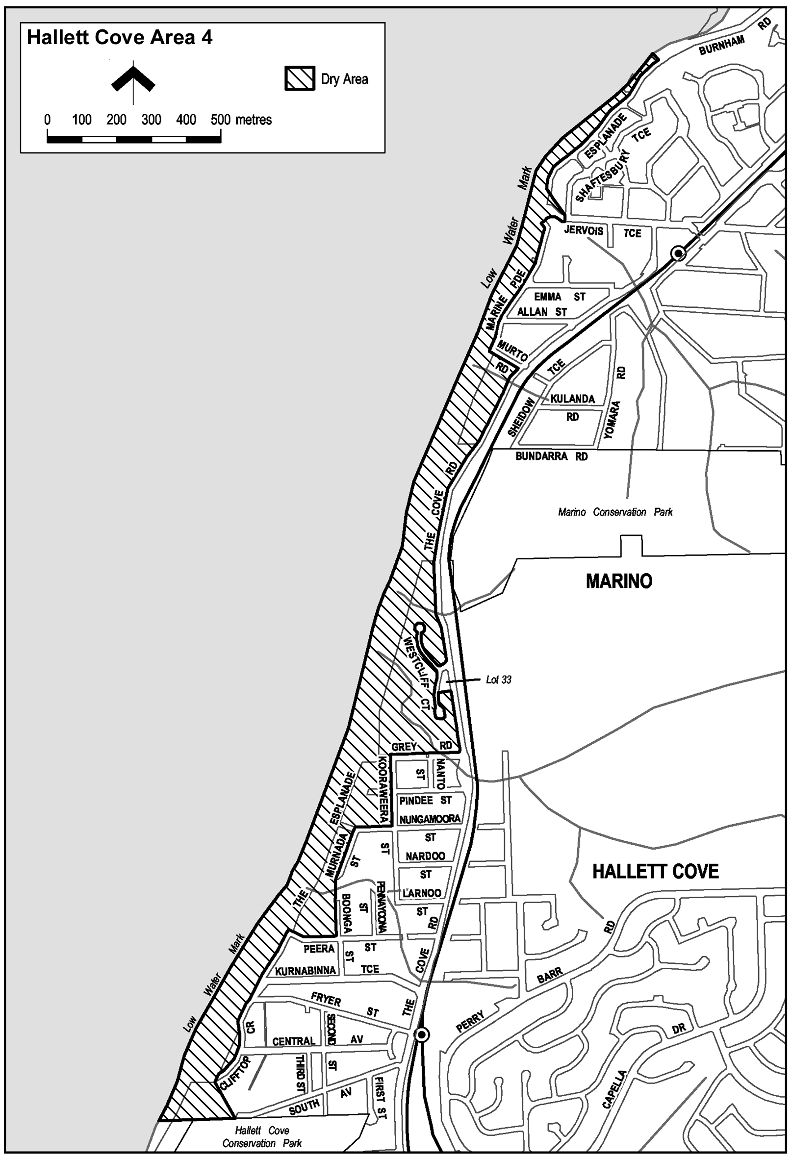
Description of area
Portion of the area known as the Coastal Walking Trail at Marino and Hallett Cove, together with other land, as follows: commencing at the western boundary of the northern end of Esplanade, Marino, then generally south-westerly and southerly along the western boundary of Esplanade to the southern end of that road, then in a straight line by the shortest route to the southern boundary of Jervois Terrace at the point which it intersects the western boundary of Shaftesbury Terrace, then westerly along that southern boundary of Jervois Terrace to the western boundary of Marine Parade, then generally south-westerly, southerly and south-easterly along the western boundary of Marine Parade and the southern boundary of Murto Road to the western boundary of The Cove Road, then generally south-westerly and southerly along that boundary of The Cove Road to the point at which it intersects the northern boundary of Westcliff Court, then westerly, north-westerly, south-easterly, south-westerly and north-easterly around the outer boundary of Westcliff Court to the southern boundary of Westcliff Court Reserve (Lot 33 Cove Road, CT 5406/175), then easterly along that southern boundary of the Reserve to the western boundary of The Cove Road, then southerly along that boundary of The Cove Road to the point at which it intersects the prolongation in a straight line of the northern boundary of Grey Road, Hallett Cove, then westerly along that prolongation and boundary to its intersection with the prolongation in a straight line of the western boundary of Kooraweera Street, then southerly along that prolongation and boundary of Kooraweera Street to the northern boundary of Nungamoora Street, then westerly and south-westerly along that boundary of Nungamoora Street and the western boundary of Murnada Street to the southern end of Murnada Street, then in a straight line by the shortest route to the western boundary of Boonga Street, then southerly along that boundary to the northern boundary of Peera Street, then westerly along that boundary and the prolongation in a straight line of that boundary to the western boundary of The Esplanade, then south-westerly along the western boundary to the southern end of The Esplanade, then in a straight line by the shortest route to the western boundary of the northern end of Clifftop Crescent, then generally south-westerly, southerly and south-westerly along that boundary to the southern end of Clifftop Crescent, then in a straight line by the shortest route to the northern boundary of the Hallett Cove Conservation Park at the point on that boundary that is closest to the western end of South Avenue, then westerly along that boundary of the Conservation Park and the prolongation in a straight line of that boundary to low water mark on Gulf St Vincent, then generally north-easterly along the low water mark to a point closest to the northern end of Esplanade, Marino, then in a straight line by the shortest route to the point of commencement.
Map of area