Extent of prohibition
The consumption of liquor is prohibited and the possession of liquor is prohibited.
Period of prohibition
Continuous.
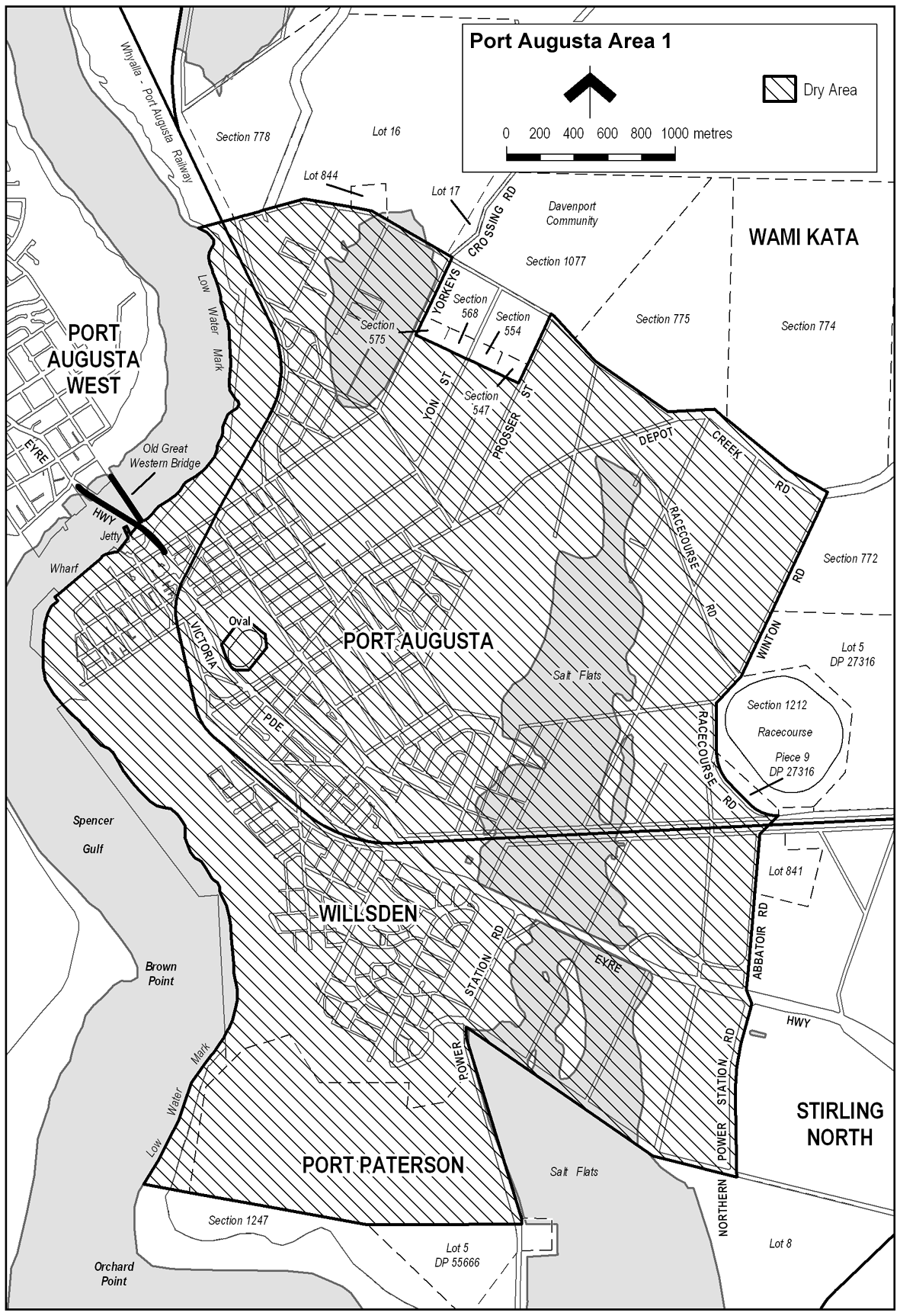
Description of area
The area in and adjacent to Port Augusta bounded as follows: commencing at the point at which the prolongation in a straight line of the southern boundary of Section 778, Hundred of Davenport intersects the low water mark on the eastern side of Spencer Gulf, then generally north-easterly and south-easterly along that prolongation and boundary of Section 778 and the southern boundaries of Allotment 16 DP 19131, Allotment 844 FP 186546 and Allotment 17 DP 19131 and the prolongation in a straight line of the southern boundary of Allotment 17 to the eastern boundary of Yorkey's Crossing Road, then south-westerly along that eastern boundary of Yorkey's Crossing Road to the southern boundary of Section 575, Hundred of Davenport, then south-easterly along that southern boundary of Section 575 and the southern boundary of Section 568, Hundred of Davenport to the south-eastern corner of Section 568, then in a straight line by the shortest route to the south-western corner of Section 554, Hundred of Davenport, then south-easterly along the southern boundary of Section 554 and of Section 547, Hundred of Davenport to the south-eastern corner of Section 547, then north-easterly along the western boundary of Prosser Street and the prolongation in a straight line of that boundary to the southern boundary of Section 1077, Hundred of Davenport, then generally south-easterly along that southern boundary of Section 1077 and of Section 775, Hundred of Davenport to the point at which that boundary of Section 775 meets the northern boundary of Depot Creek Road, then generally north-easterly and south-easterly along that boundary of Depot Creek Road to its intersection with the prolongation in a straight line of the western boundary of Section 772, Hundred of Davenport, then south-westerly along that prolongation and western boundary of Section 772 and the western boundary of Allotment 5 of DP 27316 to the eastern boundary of Racecourse Road, then generally south-westerly, southerly, south-easterly and easterly along that boundary of Racecourse Road and the southern boundary of Piece 9 DP 27316 to the south-eastern corner of Piece 9, then in a straight line by the shortest route (across the adjacent road and railway reserves) to the north-western corner of Allotment 841 FP 186543, then generally southerly along the eastern boundary of Abbatoir Road to the northern boundary of the Eyre Highway, then in a straight line by the shortest route to the point at which the southern boundary of the Eyre Highway meets the eastern boundary of Northern Power Station Road, then generally southerly along that boundary of Northern Power Station Road to the northern boundary of Allotment 8 DP 55700, then generally north-westerly along that boundary of Allotment 8 to the eastern boundary of Power Station Road, then south-easterly along that boundary of Power Station Road to its intersection with the prolongation in a straight line of the northern boundary of Allotment 5 DP 55666, then generally westerly along that prolongation and northern boundary of Allotment 5 and the northern boundary and prolongation in a straight line of the northern boundary of Section 1247, Hundred of Davenport to the low water mark on the eastern side of Spencer Gulf, then generally north-easterly, northerly, north-westerly, north-easterly and northerly along the low water mark to the point of commencement. The area includes any jetty, wharf or other structure (apart from a bridge described in Port Augusta Area 2) projecting into the Gulf from the area described above, as well as any area beneath such a structure.
Map of area