Extent of prohibition
The consumption of liquor is prohibited and the possession of liquor is prohibited.
Period of prohibition
Continuous.
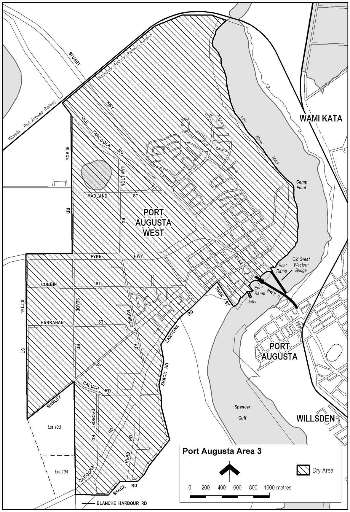
Description of area
The area in and adjacent to Port Augusta bounded as follows: commencing at the point at which the prolongation in a straight line of the western boundary of Tiver Street intersects the low water mark on the western side of Spencer Gulf, then north-westerly along that prolongation and western boundary of Tiver Street to the southern boundary of Caroona Road, then generally south-westerly along that boundary of Caroona Road to the eastern boundary of Shack Road, then generally southerly, south-westerly, westerly, south-westerly and westerly along that boundary of Shack Road to the point at which it meets the eastern boundary of Blanche Harbour Road, then in a straight line by the shortest route to the point at which the southern boundary of Caroona Road meets the western boundary of Blanche Harbour Road, then in a straight line by the shortest route to the south-eastern corner of Allotment 104 DP 50393, then generally northerly along the eastern boundary of Allotment 104 and of Allotment 103 DP 50393 to the point at which the eastern boundary of Allotment 103 meets the southern boundary of Shirley Street, then south-westerly along that boundary of Shirley Street to its intersection with the prolongation in a straight line of the western boundary of Kittel Street, then generally northerly along that prolongation and western boundary of Kittel Street and the prolongation in a straight line of that boundary to the northern boundary of the Eyre Highway, then easterly along that northern boundary of the Eyre Highway to the western boundary of Slade Road, then northerly along that boundary of Slade Road to the southern boundary of Old Tarcoola Road, then north-westerly along that boundary of Old Tarcoola Road to the point at which it meets the southern boundary of the railway reserve, then generally north-easterly and easterly along that boundary of the railway reserve to the low water mark on the western side of Spencer Gulf, then generally south-westerly, south-easterly, southerly and south-westerly along the low water mark to the point of commencement. The area includes any jetty, wharf or other structure (apart from a bridge across the Gulf) projecting into the Gulf from the area described above, as well as any area beneath such a structure.
Map of area