Extent of prohibition
The consumption of liquor is prohibited and the possession of liquor is prohibited.
Period of prohibition
Continuous, provided that where:
(a) an event of historic, cultural, traditional or major community significance is held in the area; and
(b) the consumption and possession of liquor in the area (or a defined portion of the area) are authorised for a specified period for the purposes of the event by the Port Pirie Regional Council, the prohibition does not apply in the area (or defined portion of the area) during that specified period.
The Port Pirie Regional Council may not grant authorisations under this notice in relation to more than 12 events per calendar year.
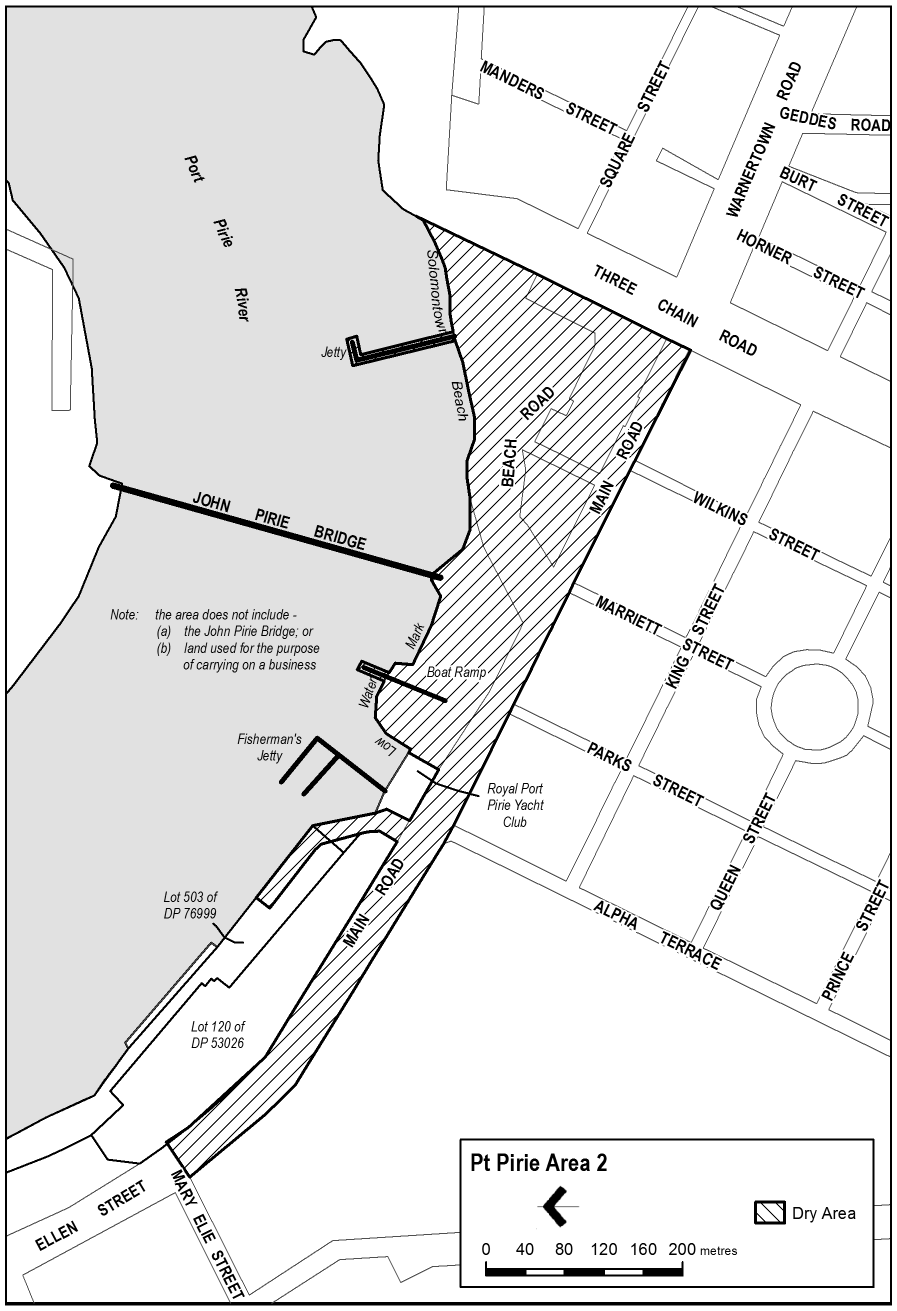
Description of area
Commencing at the point at which the prolongation in a straight line of the north-western boundary of Three Chain Road intersects the low water mark on the southern shore of the Port Pirie River, then south-westerly along that prolongation and boundary of Three Chain Road to the south-western boundary of Main Road, then north-westerly along that boundary of Main Road to the south-eastern boundary of Mary Elie Street, then north-easterly along the prolongation in a straight line of the south-eastern boundary of Mary Elie Street to the north-eastern boundary of Main Road, then south-easterly along that boundary of Main Road to the south eastern boundary of Lot 120 of DP 53026, then north-easterly along the south eastern boundary of Lot 120 to the north eastern boundary of Lot 120, then continuing north-westerly to the south eastern boundary of Lot 503 of DP, then extending north-westerly for 95 metres, then north-easterly in a straight line to the north-eastern boundary of Lot 503, then south easterly along the northern boundary of Lot 503 to the south-eastern boundary of Lot 503, then south-easterly along the low water mark to its intersection with the prolongation in a straight line of the western boundary of Alpha Terrace, then south westerly along that prolongation to the northern boundary of Main Road then easterly along the northern boundary of Main Road to the point at which it intersects the prolongation in a straight line of the south-eastern wall line of the Royal Port Pirie Yacht Club building, then north-easterly along that prolongation and wall line of the Club building, and the prolongation in a straight line of the wall line, to the low water mark on the southern shore of the Port Pirie River, then generally easterly along the low water mark extending past but excluding the John Pirie Bridge, while including the Boat Ramp and Jetty, to the point of commencement, and excluding any land used for the purpose of carrying on a business.
Map of area