Extent of prohibition
The consumption of liquor is prohibited and the possession of liquor is prohibited.
Period of prohibition
From 10 pm on each day to 8 am on the following day.
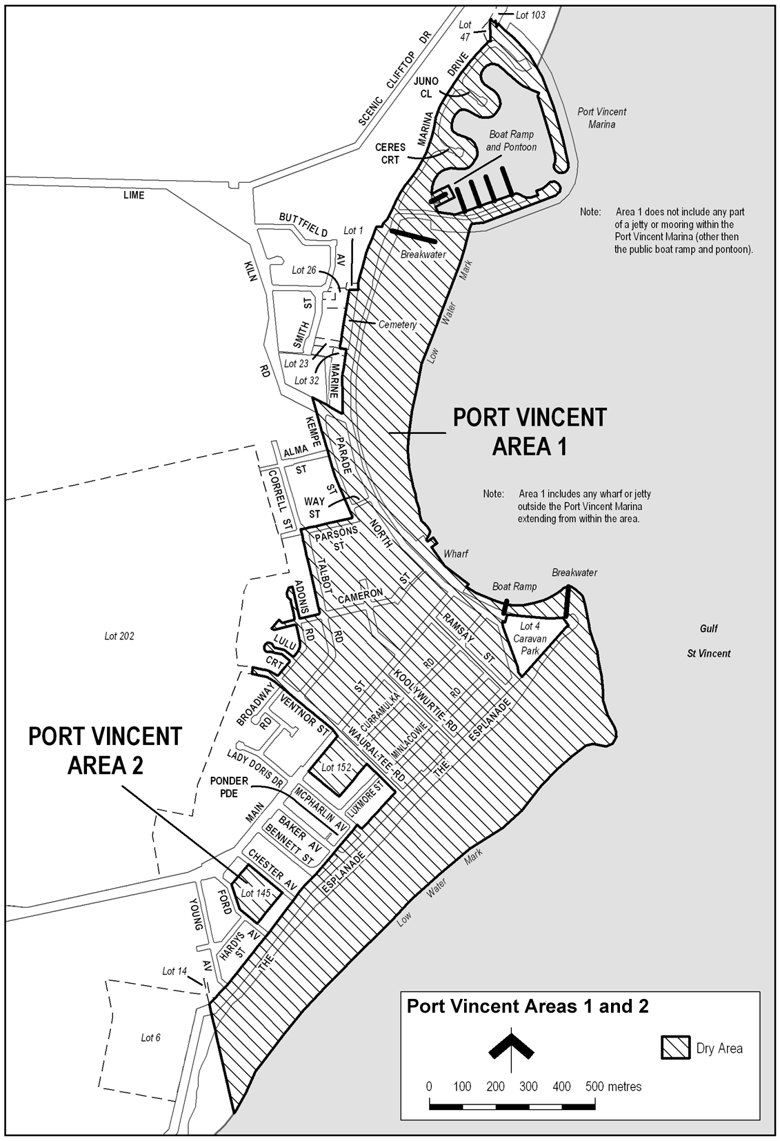
Description of area
The area in Port Vincent bounded as follows: commencing at the point at which the eastern boundary of Lot 47 DP 61751 meets the western boundary of Marina Drive, then generally south-westerly along that boundary of Marina Drive and of Marine Parade North to the point at which the western boundary of Marine Parade North meets the southern boundary of Lot 1 FP 128918, then westerly along the southern boundary of Lot 1 to the eastern boundary of Lot 26 FP 3593, then southerly along that eastern boundary of Lot 26 and of the adjoining Lots to the northern boundary of Lot 32 FP 17100, then easterly along that northern boundary of Lot 32 to the western boundary of Marine Parade North, then southerly along that boundary of Marine Parade North to the north-eastern boundary of Lime Kiln Road, then north-westerly along that boundary of Lime Kiln Road to the point at which it intersects the prolongation in a straight line of the western boundary of Kempe Street, then south-easterly along that prolongation and boundary of Kempe Street to the northern boundary of Parsons Street, then south-westerly along that boundary of Parsons Street to its intersection with the prolongation in a straight line of the western boundary of Talbot Road, then south-easterly along that prolongation and boundary of Talbot Road to the northern boundary of Cameron Street, then south-westerly along that boundary of Cameron Street to the eastern boundary of Adonis Road, then generally north-westerly, westerly and south-easterly around the boundary of Adonis Road back to the northern boundary of Cameron Street, then generally south-westerly, southerly and north-easterly around the boundary of Cameron Street back to the western boundary of Adonis Road, then south-easterly and south-westerly along that boundary of Adonis Road to the northern boundary of Lulu Court, then generally north-westerly, southerly and south-easterly around the boundary of Lulu Court back to the western boundary of Adonis Road, then south-westerly along that boundary of Adonis Road to the northern boundary of Ventnor Street, then generally westerly to the western end of Ventnor Street (the point at which it meets the eastern boundary of Lot 202 DP 62958), then southerly, easterly and south-easterly along the western and south-western boundaries of Ventnor Street to the north-western boundary of Main Street, then in a straight line by the shortest route across Main Street to the northern corner of Lot 152 DP 6070 (Bennett Park), then south-westerly, south-easterly and north-easterly along the north-western, south-western and south-eastern boundaries of Lot 152 to the south-western boundary of Wauraltee Road, then south-easterly along that boundary of Wauraltee Road to the north-western boundary of The Esplanade, then south-westerly along that boundary of The Esplanade to the north-eastern boundary of McPharlin Avenue, then north-westerly along that boundary of McPharlin Avenue to its intersection with the prolongation in a straight line of the south-eastern boundary of Ponder Parade, then south-westerly along that prolongation and boundary of Ponder Parade to the south-western end of that boundary, then in a straight line by the shortest route to the point at which the south-western boundary of Bennett Street meets the north-western boundary of The Esplanade, then south-westerly along that boundary of The Esplanade to the point at which it meets the boundary between Lot 6 DP 40247 and Lot 14 DP 43811, then south-easterly along the prolongation in a straight line of that common boundary to the point at which it intersects the low water mark on the western side of Gulf St Vincent, then generally north-easterly, easterly, north-westerly, westerly, north-westerly, northerly and north-easterly along the low water mark to the southern side of the entrance to the Port Vincent Marina, then along the low water mark inside the marina back to the entrance on the northern side of the marina, then generally north-westerly along the low water mark on the outer side of the northern breakwater of the marina to the point at which the breakwater continues north-westerly inland above the low water mark, then north-westerly along the outer boundary of the breakwater as it continues north-westerly inland to the eastern boundary of Lot 103 DP 54608, then generally south-westerly, north-westerly, south-westerly and north-westerly along the eastern and southern boundaries of Lot 103 to the eastern boundary of Lot 47 DP 61751, then southerly along that boundary of Lot 47 to the point of commencement. The area includes the public boat ramp and pontoon inside the Port Vincent Marina and any wharf or jetty outside the marina extending from the area described above, but does not include the Port Vincent Caravan Park (Lot 4 DP 24058) or any part of a jetty or mooring (other than the public boat ramp and pontoon) inside the Port Vincent Marina.
Map of area