Extent of prohibition
The consumption of liquor is prohibited and the possession of liquor is prohibited.
Period of prohibition
Continuous.
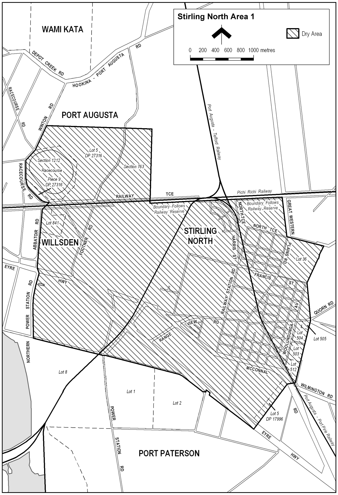
Description of area
The area in and adjacent to Stirling North and Port Augusta bounded as follows: commencing at the north-western corner of Allotment 5 DP 27316, then generally easterly along the northern boundary of Allotment 5 to the north-eastern corner of the Allotment, then in a straight line by the shortest route to the north-western corner of Section 763, Hundred of Davenport, then generally easterly and southerly along the northern and eastern boundaries of Section 763 to the south-eastern corner of the Section, then southerly along the prolongation in a straight line of the eastern boundary of Section 763 (across Railway Terrace and the adjacent railway reserve) to the southern boundary of the railway reserve, then generally north-easterly along that boundary of the railway reserve to the western boundary of Great Western Plains Road, then south-easterly along that boundary to the point at which it meets the prolongation in a straight line of the northern boundary of Allotment 36 DP 34454, then generally south-easterly and south-westerly along that prolongation and the northern and eastern boundaries of Allotment 36 to the south-eastern corner of the Allotment, then in a straight line by the shortest route (across Allotment 33 DP 17997 and Quorn Road) to the north-eastern corner of Allotment 505 FP 21299, then generally south-westerly along the eastern boundary of Allotments 505, 504, 503 and 512 of FP 21299 to the south-eastern corner of Allotment 512, then in a straight line by the shortest route (across the railway reserve and McConnal Road) to the north-eastern corner of Allotment 5 DP 17996, then generally south-westerly along the eastern boundary of Allotment 5 and the prolongation in a straight line of that boundary to the southern boundary of the Eyre Highway, then generally north-westerly along that boundary of the Eyre Highway to the point at which it meets the northern boundary of Allotment 2 DP 44849, then generally north-westerly along that boundary of Allotment 2 and the northern boundary of Allotment 1 DP 44849 to the north-western corner of Allotment 1, then in a straight line by the shortest route (across Power Station Road) to the north-eastern corner of Allotment 8 DP 55700, then generally north-westerly along the northern boundary of that Allotment to its intersection with the eastern boundary of Northern Power Station Road, then generally northerly along that boundary of Northern Power Station Road to the point at which it meets the southern boundary of the Eyre Highway, then in a straight line by the shortest route to the point at which the eastern boundary of Abbatoir Road meets the northern boundary of the Eyre Highway, then generally northerly along the eastern boundary of Abbatoir Road to the north-western corner of Allotment 841 FP 186543, then in a straight line by the shortest route (across the adjacent road and railway reserves) to the south-eastern corner of Piece 9 DP 27316, then generally westerly, north-westerly, northerly and north-easterly along the southern boundary of Piece 9 and the eastern boundary of Racecourse Road to the western boundary of Allotment 5 DP 27316, then north-easterly along that boundary of Allotment 5 to the point of commencement.
Map of area