Extent of prohibition
The consumption of liquor is prohibited and the possession of liquor is prohibited.
Period of prohibition
From 10.00pm on each day to 8.00am on the following day, provided that where—
(a) an event of historic, cultural, traditional or major community significance is held in the area; and
(b) the District Council of Loxton Waikerie authorises, for the purposes of the event, the consumption and possession of liquor in the area (or a defined part of the area) for a specified period during the event, the prohibition does not apply in the area (or defined part of the area) during the specified period.
No more than 4 authorisations may apply in relation to the area, or part of the area, in any 12 month period.
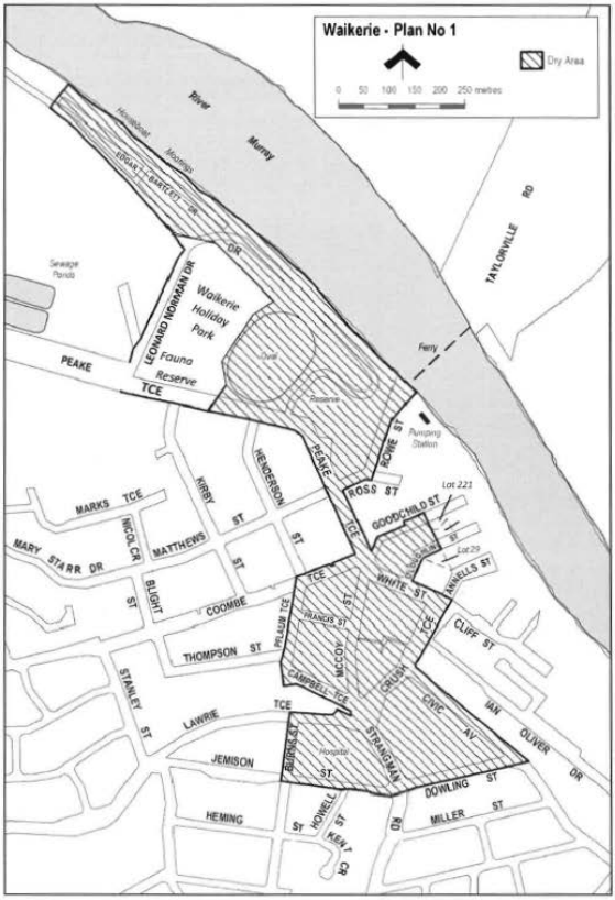
Description of area
The area in Waikerie bounded as follows: commencing at the point at which the western boundary of Burns Street intersects the southern boundary of Jemison Street, then easterly along that southern boundary of Jemison Street to the western boundary of Strangman Road, then in a straight line by the shortest route across Strangman Road to the point at which the eastern boundary of Strangman Road meets the southern boundary of Dowling Street, then north-easterly along that southern boundary of Dowling Street and the prolongation in a straight line of that boundary to the northern boundary of Civic Avenue, then north-westerly along that boundary of Civic Avenue to the eastern boundary of Crush Terrace, then north-easterly along that boundary of Crush Terrace to the point at which it meets the prolongation in a straight line of the southern boundary of White Street, then in a straight line by the shortest route to the point at which the eastern boundary of Annells Street meets the northern boundary of White Street, then north-westerly along that boundary of White Street to the eastern boundary of O'Loughlin Street, then north-easterly along that boundary of O'Loughlin Street to the point at which it meets the north-eastern boundary of Allotment 29 T701301, Hundred of Waikerie, then in a straight line by the shortest route across O'Loughlin Street to the southern corner of Allotment 221 D78368, Hundred of Waikerie, then north-westerly along the south-western boundary of Allotment 221, and the prolongation in a straight line of that boundary of Allotment 221 across Goodchild Street, to the northern boundary of Goodchild Street, then south-westerly along that boundary of Goodchild Street to the eastern boundary of Peake Terrace, then north-westerly along that boundary of Peake Terrace to the southern boundary of Ross Street, then north-easterly along that boundary of Ross Street to its intersection with the prolongation in a straight line of the eastern boundary of Rowe Street, then generally north-easterly along that prolongation and boundary of Rowe Street to the southern bank of the River Murray, then generally north-westerly along that bank of the River Murray (and around the outer boundary of any wharf, jetty, boat ramp or mooring extending into the river beyond the river bank) to a point level with the north-western end of Edgar Bartlett Drive, then in a straight line due south-west to the southern boundary of the carriageway of the formed road that runs parallel to, and is immediately to the south-west of, Edgar Bartlett Drive, then south-easterly along that boundary of the carriageway of that road, and the prolongation in a straight line of that boundary, to the eastern boundary of the carriageway of Leonard 1 September 2016 THE SOUTH AUSTRALIAN GOVERNMENT GAZETTE 3575 Norman Drive, then generally north-easterly, easterly and south-easterly along that boundary of the carriageway of Leonard Norman Drive to the point at which it meets the northern entrance from Leonard Norman Drive to the Waikerie Holiday Park, caravan and boat trailer parking area and oval, then in a straight line by the shortest route to the outer boundary of the road that circles the oval, then generally south-westerly and south-easterly along the outer boundary of that road around the western side of the oval (so as to include the whole of the oval in the area) to the western side of the entrance to the oval from Peake Terrace, then in a straight line by the shortest route across Peake Terrace to the southern boundary of Peake Terrace, then generally easterly and south-easterly along that boundary of Peake Terrace to the northern boundary of Coombe Terrace, then south-westerly along that boundary of Coombe Terrace to the western boundary of Henderson Street, then in a straight line by the shortest route across Coombe Terrace to the point at which the southern boundary of Coombe Terrace meets the western boundary of Pflaum Terrace, then south-westerly along that boundary of Pflaum Terrace to the northern boundary of Thompson Street, then in a straight line by the shortest route across Thompson Street to the point at which the southern boundary of Thompson Street meets the western boundary of Campbell Terrace, then generally southerly and south-easterly along that boundary of Campbell Terrace (and along the western boundary of the roundabout at the eastern end of Campbell Terrace) to the northern boundary of Lawrie Terrace, then generally westerly along that boundary of Lawrie Terrace to the point at which it meets the prolongation in a straight line of the western boundary of Burns Street, then generally south-westerly along that prolongation and western boundary of Burns Street to the point of commencement.
Map of area